Filter: Subject of Mines and mineral resources
Filter: Year of 1800-1899
Filter: Subject of Mines and mineral resources
Filter: Year of 1800-1899
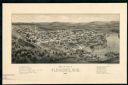
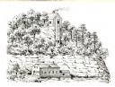
| Date: | 1881 |
|---|---|
| Description: | The county and city of Florence were named for Florence Hulst, the wife of an early settler. This view illustrates the two industries, mining and lumbering... |

| Date: | 1885 |
|---|---|
| Description: | Ore dock of the Milwaukee, Lake Shore, and Western Railroad, with a pile of logs in the foreground and docked ships in the background. |
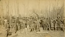
| Date: | 1886 |
|---|---|
| Description: | Outdoor group portrait of the Gogebic Range iron miners. |

| Date: | 1885 |
|---|---|
| Description: | View of the ore dock of the Milwaukee, Lake Shore, and Western Railroad. Large logs, buildings and a railroad bridge are in the foreground. |
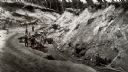
| Date: | 1855 |
|---|---|
| Description: | "Ancient copper mining on Lake Superior." |
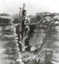
| Date: | 1836 |
|---|---|
| Description: | The shot tower at Tower Hill State Park. |

| Date: | 1849 |
|---|---|
| Description: | Geological map of the mineral region around Lake Superior, including portions of Michigan, Wisconsin, Iowa and Illinois. |

| Date: | 1847 |
|---|---|
| Description: | A hand-colored map that shows the area south and east of the Wisconsin and Fox Rivers, as well as a few landmarks just north of that area. The township gri... |

| Date: | 1842 |
|---|---|
| Description: | This map shows portions of northern Illinois and Wisconsin surveyed by the map's creation. It shows county lines and university land, and depicts lead and ... |

| Date: | 1837 |
|---|---|
| Description: | This map shows the townships, roads, trails, natural land forms, vegetation, mill sites and lead and copper deposits in the Wisconsin Territory at the time... |

| Date: | 1846 |
|---|---|
| Description: | This map shows the counties and towns in existence at the time as well as lead and copper mines. |

| Date: | 1848 |
|---|---|
| Description: | This map by Increase Lapham shows the township and range system in southern and eastern Wisconsin as well as along the Wisconsin River in present-day Marat... |

| Date: | 1849 |
|---|---|
| Description: | Published a year after Wisconsin entered statehood, this map shows the counties and towns in existence at the time - mainly in southern/southeastern Wiscon... |

| Date: | 1850 |
|---|---|
| Description: | This detailed map outlines mid and southern WI county boundaries in bright color, and city/town lines are provided. Other marks include lead mines, copper ... |

| Date: | 1851 |
|---|---|
| Description: | Map outlines mid and southern Wisconsin county boundaries in blue, and city/town lines are provided. Other marks include mines, plank roads, and railroads. |

| Date: | 1853 |
|---|---|
| Description: | Southern two thirds of Wisconsin with county boundaries hand-colored in red. The map displays towns, railroads, plan roads and mines. The scale is ten mile... |

| Date: | 1853 |
|---|---|
| Description: | Railroad map outlines mid and southern Wisconsin county boundaries in red, and city/town lines are provided. Other marks include lead mines, copper mines, ... |
If you didn't find the material you searched for, our Library Reference Staff can help.
Call our reference desk at 608-264-6535 or email us at: