 Filter: Subject of Maps

| Date: | |
|---|---|
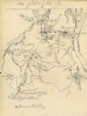
| Description: | A hand-drawn map of the state of Missouri with a separate drawing of a map showing Forts Henry and Donelson. The Missouri map includes Jefferson City and s... |
| Date: | 04 06 1862 |
|---|---|
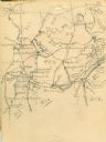
| Description: | A hand-drawn map of the Battle of Shiloh, Pittsburg Landing, Tennessee. Additional Notes include "Reserve Artillery," "Hospital," "Owl Creek," and "Snake C... |
| Date: | |
|---|---|
| Description: | A hand-drawn map of Tennessee and surrounding states. Some cities located include: St. Louis, Louisville, Cinncinati, Nashville, Murfreesboro, Knoxville, T... |

| Date: | |
|---|---|
| Description: | Poster advertising the Elmside lots for summer homes by Lake Monona. |
| Date: | 01 1947 |
|---|---|
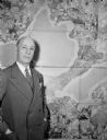
| Description: | Joseph W. Jackson (Col. Bud), executive director of the Madison and Wisconsin Foundation, standing next to a map of the isthmus. |

| Date: | 1836 |
|---|---|
| Description: | The map of Wisconsin City on the Wisconsin River. |

| Date: | |
|---|---|
| Description: | Sketch of the Fort at Michilimackinac (also called Mackinac) as it was under French rule. |
| Date: | 1905 |
|---|---|
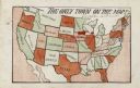
| Description: | Map of the United States with an imprint of Whitewater, Wisconsin and the title "The Only Town on the Map". It was published as a novelty. |

| Date: | 10 31 1952 |
|---|---|
| Description: | Two members of the West High School radio club, Alan Frees and Bill Reeve, operating the club's "ham" station. Observing the young men are Henry Lugg, spo... |

| Date: | 1920 |
|---|---|
| Description: | Calumet Harbor on Lake Winnebago. On the left is a map, and on the right are two images, one captioned: "Calumet Harbor". |

| Date: | 1910 |
|---|---|
| Description: | Aerial view of some of the 26 lakes known collectively as the Chain O' Lakes. Caption reads: "Aeroplane View of Chain O'Lakes, Waupaca, Wis." |

| Date: | 1971 |
|---|---|
| Description: | Secretary of Defense Melvin Laird, wearing a fatigue uniform, shaking hands with a military officer during a tour of Vietnam. |

| Date: | 1910 |
|---|---|
| Description: | Advertising poster for Osborne brand agricultural equipment produced by International Harvester for Russia. Features a map of Russia with inset color illus... |

| Date: | 1910 |
|---|---|
| Description: | Advertising poster for Plano brand agricultural machinery produced by International Harvester for Russia. Features a map of Russia with inset color illustr... |
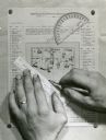
| Date: | |
|---|---|
| Description: | Person's hands, one with with wedding ring on left hand, using a ruler, pencil, and protractor to draw a land cover map for Wisconsin Land Economic Invento... |

| Date: | 1917 |
|---|---|
| Description: | The Lake Forest community plan, a model community that was planned for the site where the University of Wisconsin Arboretum now stands. |
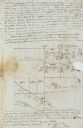
| Date: | 11 26 1846 |
|---|---|
| Description: | A drawing by Thomas Steel of his farm property contained in a letter Steel wrote to his father James Steel. |

| Date: | 04 13 1944 |
|---|---|
| Description: | Mrs. Walter S. Goodland, Wisconsin's First Lady, R.C. Tomlinson, USO Club new director, and Mrs. Tomlinson, guests of honor at a tea held at the USO Club. ... |

| Date: | 1933 |
|---|---|
| Description: | Map created by International Harvester entitled: "The United States as it appeared in 1831 when Cyrus Hall McCormick invented the Reaper." The map pinpoint... |
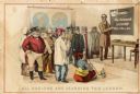
| Date: | 1899 |
|---|---|
| Description: | Back cover of an advertising catalog for D.M. Osborne and Company showing a schoolmaster in front of men from many nations. Includes the caption "all natio... |
If you didn't find the material you searched for, our Library Reference Staff can help.
Call our reference desk at 608-264-6535 or email us at: