 Filter: Subject of Archaeological sites

| Date: | 1791 |
|---|---|
| Description: | Small map of an abandoned Native American town and fort at the junction of the Ohio and Muskingum River. It shows the fortifications, an outline of the tow... |
| Date: | 11 15 1925 |
|---|---|
| Description: | View of the tomb of Queen Tin Hinan from the south. Three people are standing on top of the tomb. Mountains and the city of El Oued can be seen in the back... |

| Date: | 11 1925 |
|---|---|
| Description: | Louis Chapuis handing up a Venus statue to Count Byron de Prorok from the Tomb of Tin Hinan in Abelessa, Algeria. |

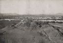
| Date: | 1930 |
|---|---|
| Description: | Poppies blooming in a field in front of a hill, right, identified by the photographer as a shell mound. The dark squares in the side of the mound are proba... |
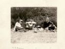
| Date: | 08 01 1929 |
|---|---|
| Description: | Charles Brown and two other men are sitting on the grass at the Shermer Indian Village site. |

| Date: | 1924 |
|---|---|
| Description: | A map of the Madison Township, T7N R9E including Lake Mendota showing the location of Ho Chunk encampments and effigy mounds. |

| Speakers Bureau |
|---|
| Caitlin Zant is a WHS Historic Preservation member and a member of the Wisconsin Historical Society Speakers Bureau. |
If you didn't find the material you searched for, our Library Reference Staff can help.
Call our reference desk at 608-264-6535 or email us at:

