 Filter: Subject of Aerial photographs
Filter: Subject of transportation
Filter: Subject of Aerial photographs
Filter: Subject of transportation

| Learn about the wide range of visual materials subjects available to view both online and in our Archives |

| Date: | 06 27 1927 |
|---|---|
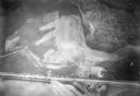
| Description: | Aerial view of the effigy mound on Henry Wehmhoff's Riverview Farm. State Trunk Highway 83 runs through the effigy. |

| Date: | 08 28 1970 |
|---|---|
| Description: | An aerial view of West Towne Shopping Center (now West Towne Mall) at Mineral Point and Gammon Roads. |

| Date: | 1950 |
|---|---|
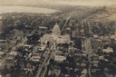
| Description: | Aerial view of the Wisconsin State Capitol building and surrounding Madison area. Lake Monona is in the background. |

| Date: | 06 07 1954 |
|---|---|
| Description: | Aerial view of the Midvale neighborhood under construction showing the intersection of Midvale and Tokay Boulevards near the southwestern city limits of Ma... |

| Date: | 07 10 1949 |
|---|---|
| Description: | Aerial view of Minocqua showing the surrounding lakes. |

| Date: | 05 09 1908 |
|---|---|
| Description: | Kite aerial panoramic photograph of the central business district. In the distance is Lake Mendota. The fire damaged Wisconsin State Capitol is in the cent... |
| Date: | 1911 |
|---|---|
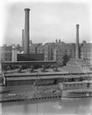
| Description: | International Harvester's McCormick Works on the river with railroad tracks and a cargo dock. The factory was owned by the McCormick Harvesting Machine Com... |

| Date: | 1942 |
|---|---|
| Description: | Aerial view of Oscar Mayer & Company, 910 Mayer Avenue at Packers Avenue. Shows stock yards, railroad cars and automobile parking lot. Also shows C.E. & P.... |
| Date: | 04 09 1931 |
|---|---|
| Description: | Aerial view of Lake Delton airport. |

| Date: | 1905 |
|---|---|
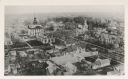
| Description: | Aerial view of town, with several large buildings along railroad tracks in the foreground, and fields and trees in the distance. Pedestrians are walking al... |

| Date: | 1930 |
|---|---|
| Description: | Aerial view of Carson Park, Half Moon Lake and part of the West Side in the foreground. The municipal bath house is on the lake shore in the foreground. A ... |

| Date: | 1956 |
|---|---|
| Description: | Aerial view, looking eastward from a point several miles outside the southwestern limits of Madison in the direction of Verona. Crossing the image diagonal... |

| Date: | 1956 |
|---|---|
| Description: | Aerial view looking east along Madison's Lake Mendota shoreline. The large building under construction at center is Carroll Hall, a University of Wisconsin... |

| Date: | 1925 |
|---|---|
| Description: | Bird's-eye view of Fountain City looking south, with high bluff on the left, and the Mississippi River on the right. Fountain City, about 4 blocks wide, ne... |

| Date: | 1955 |
|---|---|
| Description: | Aerial view of Atwood Avenue, looking west towards Winnebago Street and "Schenk's Corners." |
| Date: | 1919 |
|---|---|
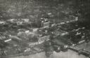
| Description: | Aerial view of the Capitol Square and surrounding area. Lake Monona and Lake Wingra are in the background. |
| Date: | 1920 |
|---|---|
| Description: | Aerial view of the commercial district on the east side of the Fox River. Left to right: Hurlbut Coal Company; suggested location for small terminal; Main... |
| Date: | 1890 |
|---|---|
| Description: | Aerial view of downtown Green Bay, with the old Court House. |
If you didn't find the material you searched for, our Library Reference Staff can help.
Call our reference desk at 608-264-6535 or email us at:
