Filter: FULL_DATE of 1858
| Date: | 1858 |
|---|---|
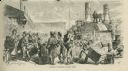
| Description: | Large group of people leaving a steam ship, some transporting large chests of their belongings. |

| Date: | 1858 |
|---|---|
| Description: | A survey map that shows the status of township surveys in Wisconsin. At that point, the majority of the state had been surveyed and platted, with the area... |

| Date: | 1858 |
|---|---|
| Description: | Front cover of a guide book describing Bayfield and an account of a pleasure tour to Lake Superior. The title is surrounded by a decorative border with flo... |

| Date: | 1858 |
|---|---|
| Description: | Drawn a decade after Wisconsin entered statehood, this 1858 map depicts counties, creeks, rivers, lakes, railroads completed, railroads in progress and com... |

| Date: | 1858 |
|---|---|
| Description: | This map shows the township survey grid and identifies counties, named towns, cities and villages, rivers, lakes, and railroads and proposed railroads in W... |

| Date: | 1858 |
|---|---|
| Description: | This map of the entire state of Wisconsin depicts the township survey grid and identifies counties, named towns, cities and villages, rivers, lakes, railro... |

| Date: | 1858 |
|---|---|
| Description: | This map shows the railroads in southern Wisconsin and their connections with points in Iowa and Illinois. An inset map shows rail connections between sout... |

| Date: | 1858 |
|---|---|
| Description: | An ink on paper map of Milwaukee County and the eastern portion of Waukesha County that shows the townships of Oak Creek, Franklin, Greenfield, Wauwatosa, ... |

| Date: | 1858 |
|---|---|
| Description: | This 1858 map shows mine shafts, lead veins, and topography on the property of the New Diggings and Shullsburg Mining Company in Section 5 of Township 1 N.... |

| Date: | 1858 |
|---|---|
| Description: | This 1858 map of Racine County, Wisconsin, shows land ownership and acreages, the township and range grid, towns, cities and villages, roads, railroads, sc... |

| Date: | 1858 |
|---|---|
| Description: | Map showing roads, mills, and rivers. Date conjectured from presence of Ensign’s Mill and Pitt’s Mill and location of Nekoosa. |

| Date: | 1858 |
|---|---|
| Description: | This 1858 map of Rock County, Wisconsin, shows the township and range grid, towns, sections, cities and villages, railroads, roads, property owners and res... |

| Date: | 1858 |
|---|---|
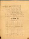
| Description: | Map of Martineau's Addition in the first ward of Milwaukee as well as buildings and location of adjacent additions with landowners names. |

| Date: | 1858 |
|---|---|
| Description: | Map shows township borders, marshes, pine timber, roads, railroads, and mills. The townships are are shown in blue/green, pink, and yellow. The map include... |
| Date: | 1858 |
|---|---|
| Description: | Map is ink and pencil on paper. Map showing Leonard's Addition to Salem Wisconsin in Kenosha County. The plats are numbered. |
| Date: | 1858 |
|---|---|
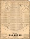
| Description: | This map is a proposed plan for a town that was never built located in present day Bayfield county, showing street names and with numbered blocks and lots.... |

| Date: | 1858 |
|---|---|
| Description: | Sixth plate daguerreotype of Minnie Claire Donnel. The portrait is a full figure sitting, turned slightly to the left and looking front, left arm bent and ... |

| Date: | 1858 |
|---|---|
| Description: | This map of Wisconsin and Minnesota shows proposed railroads, copper mines, marshes, villages, mills, reefs, notes about shorelines, and references to mini... |

| Date: | 1858 |
|---|---|
| Description: | This map is hand-colored and mounted on cloth and shows lot and block numbers and dimensions, landownership, streets, railroads, selected buildings, fair g... |
If you didn't find the material you searched for, our Library Reference Staff can help.
Call our reference desk at 608-264-6535 or email us at: