 Filter: FORMAT_TYPE of drawings
Filter: Subject of battles
Filter: FORMAT_TYPE of drawings
Filter: Subject of battles
| Date: | 10 03 1862 |
|---|---|
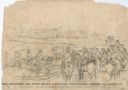
| Description: | "General Rosecranz and staff huredly [sic] erecting earthworks during the Battle at Corinth. The enemy driving in our lines." Men are on horses on a... |
| Date: | 10 03 1862 |
|---|---|
| Description: | "Combined Confederate attack upon [Batteries] Robinette and Davis the attack on Battery Robinette being defeated and that on Davis resulting in the defeat ... |
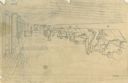
| Date: | 04 1862 |
|---|---|
| Description: | Notes include: Sketch of Battle of Island #10. Sketch of Fort Pillow Tennessee. Gen. Pope had command of the land troops. |
| Date: | 02 15 1862 |
|---|---|
| Description: | "The 2nd and 7th Iowa and the 52nd Indiana headed by General Smith storming up the rebel works at Fort Donelson causing its surrender to General Grant the ... |
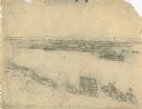
| Date: | 06 06 1862 |
|---|---|
| Description: | "Colonel Ellet's Rams approaching the city of Memphis, Tennessee, to demand its surrender." Sketch of a cityscape in the background, the river with numero... |
| Date: | 1862 |
|---|---|
| Description: | Cannons aimed out of several openings. Soldiers are working with cannons. |

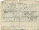
| Date: | 05 1862 |
|---|---|
| Description: | An image from a sketchbook of the "[William Stark Rosencrans'] battle at Corinth." Corinth, Mississippi, May 22-30. |

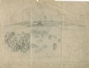
| Date: | |
|---|---|
| Description: | "Hospital and (indecipherable) during the last days battle at Fort Donelson on the Tennessee." Building with people and several trees. |

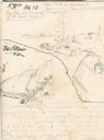
| Date: | 07 04 1776 |
|---|---|
| Description: | Hand-drawn map of the area where the Battle of Black's Fort took place. |

| Date: | |
|---|---|
| Description: | A map of the second version of the Gettysburg cyclorama created by French artist Paul Philippoteaux, as taken from the souvenir booklet which sold for five... |

| Date: | 1862 |
|---|---|
| Description: | This pen and ink drawing of the First Battle of Bull Run, JuIy 21st, 1861, was made by Charles K. Dean, adjutant with the 2nd Wisconsin Infantry. The 2nd W... |

| Date: | 1863 |
|---|---|
| Description: | This map is a hand-colored, pen and ink, drawing by Ole R. Dahl of Co. B, 15 Wisconsin Infantry shows the battlefield at Stones River, depicting roads, str... |

| Date: | 1865 |
|---|---|
| Description: | This map is a pen and ink tracing. Union positions are shown in blue and Confederate positions are shown in red. Roads, vegetation, and streams are labeled... |
If you didn't find the material you searched for, our Library Reference Staff can help.
Call our reference desk at 608-264-6535 or email us at: