 Filter: County of Sheboygan
Filter: Subject of transportation
Filter: County of Sheboygan
Filter: Subject of transportation

| Date: | 1898 |
|---|---|
| Description: | View of a horse-drawn float decorated with banners and flags and rows of pharmaceuticals on shelves. Two costumed children are posing in the back. A large ... |

| Date: | 07 02 1930 |
|---|---|
| Description: | Group portrait of four men standing outdoors under the wing of an airplane. From left to right: F.S. Brandenburg, Governor Kohler, George Charlesworth, and... |

| Date: | 1926 |
|---|---|
| Description: | This blueprint map shows the Sheboygan River, buildings, and roads in the vicinity of the harbor. The map has explanations including "dredging required to ... |

| Date: | 1926 |
|---|---|
| Description: | This map includes a legend in the lower right corner of building heights. Districts marked "A" are 35 foot, districts marked "B" are 45 foot, districts mar... |

| Date: | 1926 |
|---|---|
| Description: | This map includes a legend in the lower right corner of land use. Districts are shown in five different shading for: "A" residential, "B" are residential, ... |

| Date: | 1940 |
|---|---|
| Description: | This map hows block and lot numbers, water mains, roads, parks, the Sheboygan River and some landownership. |

| Date: | 1894 |
|---|---|
| Description: | This map shows railroads, street railways, ward lines, land parcels, streets, schools and public buildings. Ward lines are highlighted in red. Lake Michiga... |
| Date: | 1900 |
|---|---|
| Description: | This map shows the paper city situated at the mouth of the Memee (Pigeon) River in Sheboygan County, just north of Sheboygan. Land parcels, streets, and ri... |

| Date: | 1925 |
|---|---|
| Description: | This map shows trails, mounds, villages, corn fields, and contemporary civil townships; some villages and features include both Indian and English place na... |

| Date: | 1939 |
|---|---|
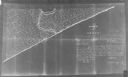
| Description: | This map originally dated March 18, 1920 and revised for this edition. The map shows the original meander line of 'Shebowegan Lake' established by 1850 sur... |

| Date: | |
|---|---|
| Description: | Because of the predominate Dutch background of people in the Cedar Grove area, it was decided by the Cedar Grove Booster Club to perpetuate this heritage w... |
| Date: | 1900 |
|---|---|
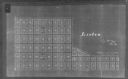
| Description: | Map showing a paper city located in section 31 of T.16N, R.20E (now in Sheboygan County, Wisconsin). The back of the map includes registration and certific... |

| Date: | |
|---|---|
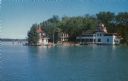
| Description: | View of the lake from a dirt road. Dwellings are on the left. A small boat is pulled up on the shoreline. |
| Date: | 1907 |
|---|---|
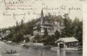
| Description: | Colorized elevated view of a large lakeside hotel inspired by castles on the Rhine. A small excursion boat is passing the dock and boathouse. Caption reads... |
| Date: | 1954 |
|---|---|
| Description: | Kodachrome print of a lakeside hotel. Text on reverse reads: "Hotel Camp Brosius on beautiful Elkhart Lake. Dining room, lounge, boat area, and round house... |

| Date: | 1954 |
|---|---|
| Description: | Elevated view towards dock, and a diving platform at Camp Brosius. A sailboat, rowboat and canoes are in the lake. Several people are swimming or standing ... |
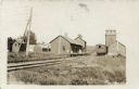
| Date: | 1908 |
|---|---|
| Description: | View alongside railroad tracks towards the railroad depot. A single freight car is on the tracks. A boy and a woman are on the platform. Caption reads: "De... |
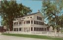
| Date: | |
|---|---|
| Description: | Color postcard view across road and fence towards of the front of the Wade House. Text on reverse reads: "Old Wade House, Greenbush, Wisconsin, 1850 St... |

| Date: | |
|---|---|
| Description: | Ektachrome postcard of the blacksmith shop next to a stream. Text on reverse reads: "The Blacksmith Shop was Sylvanus Wade's first venture in Greenbush.... |
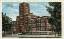
| Date: | |
|---|---|
| Description: | View of the administrative building at the Kohler Plant. Caption reads: "General Office, Kohler Co., Kohler, Wis." |
If you didn't find the material you searched for, our Library Reference Staff can help.
Call our reference desk at 608-264-6535 or email us at: