Filter: County of Juneau

| Date: | |
|---|---|
| Description: | Main Street, south. View includes cable car on track, businesses, a post office, and five people standing on the sidewalks lining street. |
| Date: | |
|---|---|
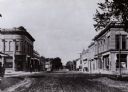
| Description: | View of Pearl Street includes a horse-drawn carriage, a bank, other commercial buildings, and a man standing on the street corner. Caption reads: "Pearl St... |
| Date: | |
|---|---|
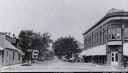
| Description: | View down unpaved street. There is a bank on the corner on the left, and people are standing on the sidewalks. |

| Date: | 1950 |
|---|---|
| Description: | Aerial view of the Highway 21 bridge and Petenwell Dam on the Wisconsin River. |
| Date: | 1924 |
|---|---|
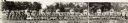
| Description: | Panoramic view of the 32nd Company W.N.G. (Wisconsin National Guard). Depicts company members, including two cooks (left panel), and small tanks spaced un... |
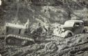
| Date: | |
|---|---|
| Description: | Men with a tractor attempt to pull out a car stuck in the mud on an early road. |
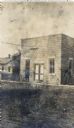
| Date: | |
|---|---|
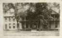
| Description: | A man stands in front of the small building with a bicycle parked behind him, and a house in the background. |

| Date: | 1926 |
|---|---|
| Description: | This hand-colored blueprint map shows landowners in part of T15N, R5E in Juneau County. North is oriented to the right. |

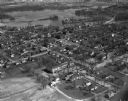
| Date: | 03 16 1949 |
|---|---|
| Description: | Aerial view of Mauston, Wisconsin. |
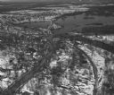
| Date: | 04 16 1949 |
|---|---|
| Description: | Aerial view of Necedah, Wisconsin, and Petenwell Lake behind Petenwell Dam on the Wisconsin River. |
| Date: | 04 16 1949 |
|---|---|
| Description: | Aerial view of Castle Rock Dam on the Wisconsin River near Mauston, Wisconsin. |
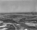
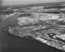
| Date: | 04 16 1949 |
|---|---|
| Description: | Aerial view of Petenwell Dam and dike on Wisconsin River twenty miles north of Necedah, Wisconsin showing the early formation of Lake Petenwell. |
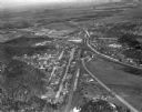
| Date: | 04 27 1949 |
|---|---|
| Description: | Camp Douglas with Volk Field in the background. |
| Date: | 04 27 1949 |
|---|---|
| Description: | Aerial view of New Lisbon. |
| Date: | |
|---|---|
| Description: | People involved in activity at the Wonewoc Spiritualist Camp. A "test" is being performed to see if a medium is authentic. |
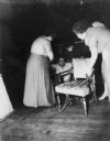
| Date: | |
|---|---|
| Description: | A "test" being performed to see if a medium is authentic. |
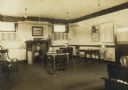
| Date: | |
|---|---|
| Description: | Interior view of the Elroy Public Library. The library opened in 1908 and was funded by Andrew Carnegie with $10,000. On the lower right the cardboard back... |
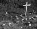
| Date: | 09 25 1960 |
|---|---|
| Description: | A cemetery for pets near Highway 58. Each burial plot is marked with a small wooden cross. Additionally, several plots have accompanying makeshift tombston... |
If you didn't find the material you searched for, our Library Reference Staff can help.
Call our reference desk at 608-264-6535 or email us at: