 Filter: Community of Racine
Filter: Subject of human settlements
Filter: Community of Racine
Filter: Subject of human settlements
| Date: | 1870 |
|---|---|
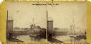
| Description: | View of a lumber hooker ship at dock on the Root River. The 4th St. bridge spans the river at center. The Racine Woolen Mill is visible at right behind the... |

| Date: | 1874 |
|---|---|
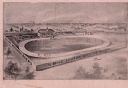
| Description: | Engraved view of downtown Racine seen from Lake Michigan. Several vessels are entering the harbor, and a pier with a beacon is on the right. |
| Date: | 1897 |
|---|---|
| Description: | Aerial view drawing of a velodrome with racers on the oval track and stands full of spectators. Signage on the outer wall indicates that it is the Racine A... |

| Date: | 1903 |
|---|---|
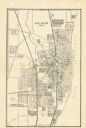
| Description: | Map shows location of government buildings, schools, churches, parks, and other points of interest. The upper left hand margin features a "Reference" secti... |

| Date: | 1921 |
|---|---|
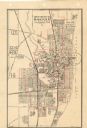
| Description: | This map of Racine is oriented with north to the right and shows labeled streets, Lake Michigan, and points of interest. There are manuscript annotations i... |
| Date: | 1947 |
|---|---|
| Description: | This map of Racine has labeled streets, the Root River, Lake Michigan, and includes manuscript annotations of newly annexed areas and African-American neig... |

| Date: | 1956 |
|---|---|
| Description: | This map of Racine includes a street directory and index of public buildings. Streets, points of interest, Lake Michigan, and the Root River are labeled. A... |

| Date: | 1950 |
|---|---|
| Description: | This map of Racine's business section is oriented with the north to the right and shows businesses and lot owners. Businesses, streets, and the Root River ... |

| Date: | 1951 |
|---|---|
| Description: | This map of Racine Harbor has relief shown by contours and depths shown by gradient tints and soundings in feet. The map also shows Racine Reef, Wind Point... |
| Date: | 1950 |
|---|---|
| Description: | This map shows streets and waterways and includes annotations in red outlining wards. |

| Date: | 1935 |
|---|---|
| Description: | This map includes an index on the right margin of industrial plants, churches, schools, and public buildings. Streets, the Rock River, Lake Michigan, parks... |

| Date: | 1883 |
|---|---|
| Description: | This map shows lots, neighborhood additions and subdivisions (some in blue, green, pink, and yellow), and numbered wards. Streets, Lake Michigan, and the R... |

| Date: | 1904 |
|---|---|
| Description: | This map is mounted on cloth and shows streets, railways, and city wards. A stamp in the right margin reads: "The Library of Congress, one copy received Fe... |

| Date: | 1858 |
|---|---|
| Description: | This map shows lot and block numbers, landownership, buildings, railroads, roads, wards, points of interest, parks, and cemeteries. Also included are illus... |

| Date: | 01 18 1907 |
|---|---|
| Description: | This map shows Lake Michigan, streets, schools, churches, businesses, cemeteries, parks, and railroads. Relief is shown by contours; depths are shown by so... |

| Date: | 12 10 1957 |
|---|---|
| Description: | Pleasure boat ramps, made of timber, on the south side of Racine Harbor. A man is walking in the snow near the ramps. There are piles of material along the... |
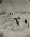
| Date: | 03 1881 |
|---|---|
| Description: | Winter scene with men digging out the train tracks by hand after a big snow storm. Trees and a fence line the sides of the railroad right of way. Between F... |
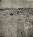
| Date: | 03 1881 |
|---|---|
| Description: | A winter scene with men digging out the train tracks by hand after a big snow storm in Racine County. Trees and a fence line the sides of the railroad righ... |

| Date: | 12 20 1957 |
|---|---|
| Description: | View across harbor from small boat ramp towards far shoreline. On the far shoreline is industrial machinery, piles of coal, and other buildings. |

| Date: | 1867 |
|---|---|
| Description: | This map shows components of the bottom of Lake Michigan and the Root River, as well as the harbor, buildings, streets, railroads, and rural landowners in ... |
If you didn't find the material you searched for, our Library Reference Staff can help.
Call our reference desk at 608-264-6535 or email us at: