 Filter: Categories of Wisconsin Historical Images
Filter: State of Virginia
Filter: Year of 1800-1899
Filter: Categories of Wisconsin Historical Images
Filter: State of Virginia
Filter: Year of 1800-1899

| Date: | 1865 |
|---|---|
| Description: | This detailed map of the area between Richmond and Petersburg shows fortifications, roads, railroads, towns, street patterns of Petersburg and Richmond, dr... |
| Date: | 1865 |
|---|---|
| Description: | This map shows the seven raids made in central Virginia by cavalry under the command of Maj. Gen. Philip H. Sheridan between May 9, 1864, and May 3, 1865. |

| Date: | 1865 |
|---|---|
| Description: | The map of the battlefield shows entrenchments, villages, roads, the "South Side Rail Road" drainage, vegetation, relief by hachures, houses, and names of ... |

| Date: | 1862 |
|---|---|
| Description: | This map consists of four separate panels. The first illustrates the battlefield at Cedar Mountain on Aug. 9, 1862, where the 3rd Wisconsin Infantry fought... |

| Date: | 11 1860 |
|---|---|
| Description: | Confederate Presidential Election ballot. Jefferson Davis and Alex. H. Stephens were elected without opposition. The corrosion on the front is caused by th... |

| Date: | 11 06 1860 |
|---|---|
| Description: | National Democratic Ticket for the United States Presidential Election, Stephen A. Douglas and for Vice President, Herschel V. Johnson. Voters that desired... |
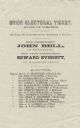
| Date: | 11 06 1860 |
|---|---|
| Description: | Union Electoral Ticket for the United States Presidential Election, John Bell and for Vice President, Edward Everett. Voters that desired to select a strai... |

| Date: | 1863 |
|---|---|
| Description: | Quarter plate ferrotype/tintype of Lieutenant Albert Lamson, taken at Falmouth, Virginia. Lamson is posed, in military uniform, seated and holding a sword ... |

| Date: | 1862 |
|---|---|
| Description: | This map shows the plan of the siege of Yorktown and the Battle of Williamsburg. The map also shows fortifications, towns, roads, houses, names of resident... |

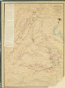
| Date: | 1865 |
|---|---|
| Description: | This map shows U.S. cavalry positions in yellow, Confederate infantry positions in blue, and Confederate cavalry positions in red. The map also shows roads... |

| Date: | 1865 |
|---|---|
| Description: | This map shows Union and Confederate lines on May 5th, 6th, and 7th, 1864. The lower left corner includes a key of symbols for batteries, turnpikes, plank ... |
If you didn't find the material you searched for, our Library Reference Staff can help.
Call our reference desk at 608-264-6535 or email us at: