 Filter: Categories of Wisconsin Historical Images
Filter: State of Virginia
Filter: Year of 1800-1899
Filter: Subject of transportation
Filter: Categories of Wisconsin Historical Images
Filter: State of Virginia
Filter: Year of 1800-1899
Filter: Subject of transportation

| Date: | 02 21 1874 |
|---|---|
| Description: | African American boatmen run a rapids in a small river boat. |
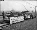
| Date: | 1899 |
|---|---|
| Description: | Group of people posing on a trolley car, which is pulling a flat car loaded with a McCormick grain binder and mower as part of an event culminating the "Cr... |
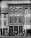
| Date: | 1899 |
|---|---|
| Description: | Elevated view from across street of men posing with farm and lawn equipment along the storefront of a McCormick Harvesting Machine Company dealership. Thre... |
| Date: | 06 1862 |
|---|---|
| Description: | The 7th Wisconsin Volunteer Infantry Regiment camp outside of Fredericksburg on the east side of the Rappahannock. Fredericksburg and a pontoon bridge lea... |
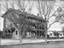
| Date: | 1885 |
|---|---|
| Description: | Engraved illustration of "Walnut Grove," the "homestead of the McCormick family" in Rockbridge County, Virginia. Cyrus Hall McCormick developed the first s... |
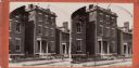
| Date: | 1864 |
|---|---|
| Description: | Marshall House, in which Col. E.E. Ellsworth was shot on May 24, 1861. |
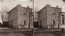
| Date: | 1864 |
|---|---|
| Description: | A stereograph of exterior of General Lee's residence. |
| Date: | 1871 |
|---|---|
| Description: | Stereograph of exterior of a building used as the Confederate government's Executive Mansion. This was where Jefferson Davis and his family stayed during t... |

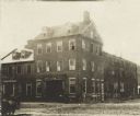
| Date: | 1890 |
|---|---|
| Description: | People with horses and wagons are congregated at the railroad depot. |
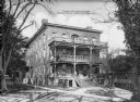
| Date: | 1872 |
|---|---|
| Description: | A view of the female residence at Hampton Institute. The left side of the front porch contains potted plant,s and three women converse near the steps. Anot... |
| Date: | 1878 |
|---|---|
| Description: | A view of the Native American male dormitory, called "Wigwam." The structure has three floors, each with a balcony. A smaller building is next to it on the... |

| Date: | 1862 |
|---|---|
| Description: | This map shows the region of southeastern Virginia which served as the setting for the Peninsular Campaign of 1862. A few battle sites are marked by crosse... |

| Date: | 1864 |
|---|---|
| Description: | This colored map shows cities, rail lines, and geographic features in eastern Virginia. Circles around Richmond at 10 mile intervals indicate distances fro... |

| Date: | 1864 |
|---|---|
| Description: | This map of the battlefield at Wilderness, Virginia, illustrates the Union positions in blue and Confederate positions in red. Roads, railroads, vegetation... |

| Date: | 1864 |
|---|---|
| Description: | This battlefield map of the Battle of Totopotomoy Creek, also known as the Battle of Bethesda Church, shows the railroads, roads, vegetation and topography... |

| Date: | 1864 |
|---|---|
| Description: | This battlefield map of the Battle of Totopotomoy Creek, also known as the Battle of Bethesda Church, shows the railroads, roads, vegetation and topography... |

| Date: | 1864 |
|---|---|
| Description: | This map of the area of the First Battle of Bull Run shows military positions and troop movements as well as the names of landowners, vegetation and land u... |

| Date: | 1864 |
|---|---|
| Description: | This map created during the Civil War indicates Confederate fortifications, houses, names of residents, towns, roads, railroads, relief by hachures, draina... |

| Date: | 1865 |
|---|---|
| Description: | This map of the battlefield at Spotsylvania Courthouse illustrates the Union positions in blue and Confederate positions in red. Roads, railroads, vegetati... |
If you didn't find the material you searched for, our Library Reference Staff can help.
Call our reference desk at 608-264-6535 or email us at:
