 Filter: Categories of Wisconsin Historical Images
Filter: State of Virginia
Filter: Subject of social issues
Filter: Categories of Wisconsin Historical Images
Filter: State of Virginia
Filter: Subject of social issues
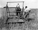
| Date: | 1929 |
|---|---|
| Description: | Re-enactors demonstrating a replica of the first reaper built by Cyrus Hall McCormick in 1831. The man raking at the back of the reaper appears to be playi... |
| Date: | 1929 |
|---|---|
| Description: | Re-enactors demonstrating a replica of the first reaper built by Cyrus Hall McCormick in 1831. The man raking at the back of the reaper appears to be playi... |
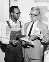
| Date: | 04 27 1963 |
|---|---|
| Description: | Charles Sherrod and Carl Braden looking over a "Time for Action" paper. |
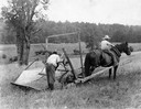
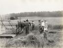
| Date: | 1929 |
|---|---|
| Description: | Scene from the film "Romance of the Reaper" showing the building of the first practical reaper on the McCormick farm in Virginia. Actors playing the parts ... |
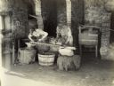
| Date: | 1929 |
|---|---|
| Description: | A production still from the Fox Hearst film "Romance of the Reaper". The film was produced by International Harvester at Walnut Grove to celebrate the Reap... |

| Date: | 1880 |
|---|---|
| Description: | James Dorman Davidson (1810-1882) sits in profile in a plush chair for a studio portrait in front of a backdrop. He is wearing a wide hat, suit jacket, bow... |
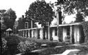
| Date: | |
|---|---|
| Description: | Exterior view of the slave quarters at Monticello, built in 1772 by Thomas Jefferson. |
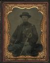
| Date: | 1863 |
|---|---|
| Description: | Quarter plate ferrotype/tintype of Lieutenant Albert Lamson, taken at Falmouth, Virginia. Lamson is posed, in military uniform, seated and holding a sword ... |

| Date: | 1770 |
|---|---|
| Description: | The south west sheet of a four sheet map of Virginia, showing the counties, mountains, rivers, court houses, a few cities, and mills. A few Plantations ar... |

| Date: | 1755 |
|---|---|
| Description: | Map of Virginia and parts of Maryland, North Carolina, and New Jersey. It shows borders, boundary lines, some Native American land, counties, cities, towns... |
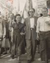
| Date: | 1942 |
|---|---|
| Description: | Several people marching together. A man and woman are marching in the front next to each other; the woman is holding a cigarette. A sign reads: "[Danville]... |
If you didn't find the material you searched for, our Library Reference Staff can help.
Call our reference desk at 608-264-6535 or email us at: