 Filter: Categories of Wisconsin Historical Images
Filter: State of Virginia
Filter: Subject of indians of north america
Filter: Categories of Wisconsin Historical Images
Filter: State of Virginia
Filter: Subject of indians of north america
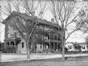
| Date: | 1878 |
|---|---|
| Description: | A view of the Native American male dormitory, called "Wigwam." The structure has three floors, each with a balcony. A smaller building is next to it on the... |

| Date: | |
|---|---|
| Description: | A hand-drawn map of Indian boundary lines in southwest Virginia. It also includes the Duck River and the Elk River. |

| Date: | 1671 |
|---|---|
| Description: | Map of Virginia depicting the discoveries detailed by John Smith in his exploration of the region. It shows Jamestown, Native American tribes and villages,... |

| Date: | 1755 |
|---|---|
| Description: | Map of Virginia and parts of Maryland, North Carolina, and New Jersey. It shows borders, boundary lines, some Native American land, counties, cities, towns... |

| Date: | 1762 |
|---|---|
| Description: | Map of Virginia and parts of Maryland. It shows borders, boundary lines, Native American tribes and land, towns, forts, roads, mountains, waterfalls, bays,... |
If you didn't find the material you searched for, our Library Reference Staff can help.
Call our reference desk at 608-264-6535 or email us at: