Filter: Categories of Wisconsin Historical Images
Filter: State of South Carolina
Filter: Subject of water
Filter: Categories of Wisconsin Historical Images
Filter: State of South Carolina
Filter: Subject of water
| Date: | |
|---|---|
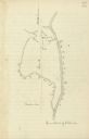
| Description: | Drawn map of the Catawba River, fishing creek, and surrounding landscape from the Sumter Papers. |
| Date: | 1869 |
|---|---|
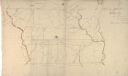
| Description: | Hand-drawn map of York County, South Carolina. |
| Date: | 08 1938 |
|---|---|
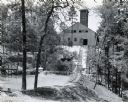
| Description: | Mine building at a gold and mica mine operated by the Mineral Mining Corporation. A body of water is in the foreground on the left side of a partially cons... |

| Date: | |
|---|---|
| Description: | View toward people standing on large rocks in a river. The people are dispersed across the wide river and the river is lined by trees. |
| Date: | |
|---|---|
| Description: | View from shoreline toward two men and a woman seated in a boat, traveling through the water at Cypress Gardens. |
| Date: | |
|---|---|
| Description: | View from shoreline toward people boating in Cypress Gardens. Two boats are visible, holding both men and women. |

| Date: | 1915 |
|---|---|
| Description: | View across water toward Fort Sumter. Caption reads: "Fort Sumter, Charleston, S. C." |

| Date: | |
|---|---|
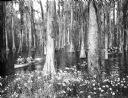
| Description: | A small group sits under an ivy-covered arbor which covers what appears to be a fresh water well. The arbor is set in the woods and bears a horse-shoe shap... |
| Date: | |
|---|---|
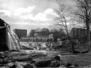
| Description: | View of a mill dam and falls on the Saluda River with buildings in the background. |

| Date: | 1927 |
|---|---|
| Description: | The Beaufort river waterfront as seen from Lady's Island bridge. There are wooden buildings, piers and a tree-line in the background. |

| Date: | |
|---|---|
| Description: | Logging scene on Waccamaw River. On the right is a group of logs floating in a contained area in front of a boat. In the background on the left is another... |
| Date: | |
|---|---|
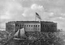
| Description: | A painting of a harbor view of Fort Sumter. A sailboat sails through the foreground waters, and the fort is in the background, with a United States flag wa... |
| Date: | |
|---|---|
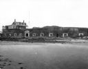
| Description: | A view of Fort Moultrie from across a body of water. A doorway leads into the fort, and to the left a sign reads, "Cable Crossing Do Not Anchor." Past the ... |

| Date: | 1866 |
|---|---|
| Description: | Exterior of Fort Sumter. A cannon has fallen on the steep shoreline and waves are hitting the rocks. Plate 58 |

| Date: | 1865 |
|---|---|
| Description: | Exterior of Fort Sumpter [sic]. There are several men and a boat on the shoreline in the foreground. Plate 56 |

| Date: | |
|---|---|
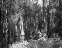
| Description: | View of Cypress Gardens, featuring a group of trees reflected in the water. |

| Date: | 1780 |
|---|---|
| Description: | This map shows the townships, parishes, cities, towns, plantations, lakes, rivers, swamps, and roads near the coast of South Carolina and Georgia. Emphasis... |

| Date: | 1779 |
|---|---|
| Description: | Map of South Carolina showing boundary lines, Native American land, precincts, townships, cities, towns, forts, roads, mountains, hills, swamps, islands, a... |

| Date: | 1795 |
|---|---|
| Description: | Map of South Carolina showing the precincts, cities, towns, Native American villages (marked with a triangle), courthouses, roads, mountains, swamps, islan... |
If you didn't find the material you searched for, our Library Reference Staff can help.
Call our reference desk at 608-264-6535 or email us at: