 Filter: Categories of Wisconsin Historical Images
Filter: State of South Carolina
Filter: Subject of transportation
Filter: Categories of Wisconsin Historical Images
Filter: State of South Carolina
Filter: Subject of transportation
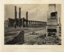
| Date: | 1865 |
|---|---|
| Description: | The ruins of a railroad depot after General Sherman's men burned the town near the end of the Civil War. Plate 61 |
| Date: | 1865 |
|---|---|
| Description: | The ruins of Charleston after General Sherman's men burned the town near the end of the Civil War. A man, smoking a pipe, and a boy sit on the shoreline of... |

| Date: | 1866 |
|---|---|
| Description: | Exterior of Fort Sumter. A cannon has fallen on the steep shoreline and waves are hitting the rocks. Plate 58 |

| Date: | 1865 |
|---|---|
| Description: | Exterior of Fort Sumpter [sic]. There are several men and a boat on the shoreline in the foreground. Plate 56 |
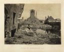
| Date: | 1866 |
|---|---|
| Description: | Destruction of Columbia after General Sherman's men burned the town near the end of the Civil War. Plate 53 |

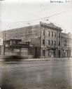
| Date: | |
|---|---|
| Description: | Street scene featuring carriages, pedestrians, and storefronts. |
| Date: | 1925 |
|---|---|
| Description: | A is man looking out the window of the second story of the International Harvester Company's Columbia branch building. A sign is hanging above the main ent... |

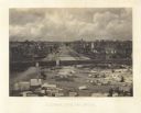
| Date: | 1920 |
|---|---|
| Description: | Exterior view across field of the International Harvester Company Charlotte branch building. The main factory building is surrounded by a series of smaller... |
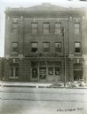
| Date: | 1925 |
|---|---|
| Description: | Exterior view of the International Harvester Company Columbia branch building. Brick buildings stand on either side; to the left is a building bearing the ... |
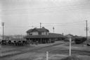
| Date: | |
|---|---|
| Description: | Exterior view of Orangeburg Railroad Station with horse-drawn omnibuses waiting near the tracks. |

| Date: | 1780 |
|---|---|
| Description: | This map shows the townships, parishes, cities, towns, plantations, lakes, rivers, swamps, and roads near the coast of South Carolina and Georgia. Emphasis... |

| Date: | 1779 |
|---|---|
| Description: | Map of South Carolina showing boundary lines, Native American land, precincts, townships, cities, towns, forts, roads, mountains, hills, swamps, islands, a... |

| Date: | 1795 |
|---|---|
| Description: | Map of South Carolina showing the precincts, cities, towns, Native American villages (marked with a triangle), courthouses, roads, mountains, swamps, islan... |
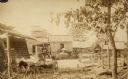
| Date: | |
|---|---|
| Description: | View of the cotton gin. A man is driving a small cart in the left foreground. Men are standing in front of cotton gin buildings in the background. |
If you didn't find the material you searched for, our Library Reference Staff can help.
Call our reference desk at 608-264-6535 or email us at: