Filter: Categories of Wisconsin Historical Images
Filter: State of South Carolina
Filter: Reproduction Rights of For Sale
Filter: Categories of Wisconsin Historical Images
Filter: State of South Carolina
Filter: Reproduction Rights of For Sale
| Date: | 1925 |
|---|---|
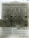
| Description: | A is man looking out the window of the second story of the International Harvester Company's Columbia branch building. A sign is hanging above the main ent... |

| Date: | 1920 |
|---|---|
| Description: | Exterior view across field of the International Harvester Company Charlotte branch building. The main factory building is surrounded by a series of smaller... |
| Date: | 1925 |
|---|---|
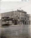
| Description: | Exterior view of the International Harvester Company Columbia branch building. Brick buildings stand on either side; to the left is a building bearing the ... |
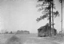
| Date: | |
|---|---|
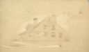
| Description: | Exterior view of a small cabin located near a cotton field. There is a cemetery in the far background. |
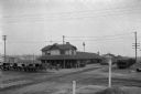
| Date: | |
|---|---|
| Description: | Exterior view of Orangeburg Railroad Station with horse-drawn omnibuses waiting near the tracks. |
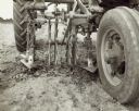
| Date: | 1947 |
|---|---|
| Description: | Close-up of a Farmall M with HM-236 cultivator and rotary hoe attachment cultivating cotton at the Edisto Experimental Station, Clemson College. |

| Date: | 1780 |
|---|---|
| Description: | This map shows the townships, parishes, cities, towns, plantations, lakes, rivers, swamps, and roads near the coast of South Carolina and Georgia. Emphasis... |

| Date: | 1779 |
|---|---|
| Description: | Map of South Carolina showing boundary lines, Native American land, precincts, townships, cities, towns, forts, roads, mountains, hills, swamps, islands, a... |

| Date: | 1795 |
|---|---|
| Description: | Map of South Carolina showing the precincts, cities, towns, Native American villages (marked with a triangle), courthouses, roads, mountains, swamps, islan... |
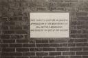
| Date: | |
|---|---|
| Description: | Slab at a school that reads: "This tablet is erected in grateful appreciation of the munificence of Mrs. Nettie F. McCormick, who donated the site of this ... |
| Date: | |
|---|---|
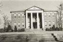
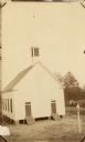
| Description: | Slightly elevated view of the front of the Baptist Church. |

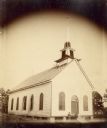
| Date: | |
|---|---|
| Description: | A man wearing a hat and carrying a coat over his arm is standing in the left foreground. Beyond is a town, with a building under construction. Caption read... |
| Date: | |
|---|---|
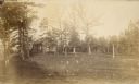
| Description: | View through trees of the old school house. A number of trees in the foreground have been cut down, leaving an open area of stumps. |
| Date: | |
|---|---|
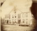
| Description: | People posing on the porch and inside the upper windows of the McCormick Hotel. A woman is standing in the open doorway. There are doors on the second stor... |
| Date: | |
|---|---|
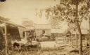
| Description: | View of the cotton gin. A man is driving a small cart in the left foreground. Men are standing in front of cotton gin buildings in the background. |
| Date: | |
|---|---|
| Description: | Slightly elevated view of two men standing in front of a church building. The arched windows have wooden shutters. The tower on the roof has scaffolding ar... |
If you didn't find the material you searched for, our Library Reference Staff can help.
Call our reference desk at 608-264-6535 or email us at: