 Filter: Categories of Wisconsin Historical Images
Filter: State of Pennsylvania
Filter: Year of 1800-1899
Filter: Categories of Wisconsin Historical Images
Filter: State of Pennsylvania
Filter: Year of 1800-1899
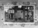
| Date: | 1895 |
|---|---|
| Description: | View of the two-story Girard, Pennsylvania home of Dan Rice (1/23/1823 – 2/22/1900), entertainer and circus performer widely regarded as "America's most fa... |
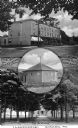
| Date: | 1890 |
|---|---|
| Description: | Composite image combining Girard, Pennsylvania landmarks. At the top is "The Old Keystone," in the center is "The Dan Rice Ring Barn," and at the bottom is... |

| Date: | 1895 |
|---|---|
| Description: | Wheatland estate, the 22-acre residence of James Buchanan, was built in 1828 by William Jenkins. Caption reads: "'Wheatland' Home of President Buchanan." |

| Date: | 1860 |
|---|---|
| Description: | View of an old cabin, built in 1860, on the grounds of the Bedford Springs Hotel. In the foreground is a dirt road, and a pedestrian is walking near the fe... |
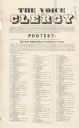
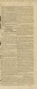
| Date: | 09 1863 |
|---|---|
| Description: | Proclamation made by the Episcopal Clergy of Philadelphia protesting the statement made by John Henry Hopkins, Bishop of the Diocese of Vermont, supporting... |

| Date: | 1894 |
|---|---|
| Description: | Stereograph view of the banquet hall for the 28th National Encampment of the Grand Army of the Republic. A man stands on the far right. |
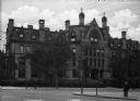
| Date: | 1881 |
|---|---|
| Description: | A view of Logan Hall, home to the Wharton School of Business. The building features Gothic Revival elements, including the arched windows and quatrefoils f... |
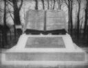
| Date: | 1890 |
|---|---|
| Description: | "Commands Honored" monument in the form of a large bronze book opened to pages reading "High Water Mark on the Rebellion" and "Repulse of Longstreet's Assa... |
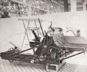
| Date: | 1876 |
|---|---|
| Description: | A Withington wire binder sits on display inside a building at the Centennial Exposition, the first official World's Fair in the United States. |
| Date: | 11 01 1875 |
|---|---|
| Description: | Erected in Girard, Pennsylvania, in 1875 to the memory of soldiers in the Civil War. Likeness of "Old Abe" appears on the top of the monument. On the botto... |

| Date: | 09 27 1876 |
|---|---|
| Description: | Certificate presented to the State of Wisconsin for the "Bald-Headed Eagle 'Old Abe'" from the United States Centennial Commission. Presented in Philadelp... |

| Date: | 1894 |
|---|---|
| Description: | Stereograph view of the banquet hall for the 28th National Encampment of the Grand Army of the Republic. A man is standing on the far right. |

| Date: | 1864 |
|---|---|
| Description: | This map of the Battle of Gettysburg indicates Union positions in red and Confederate positions in blue. Also shown are artillery positions, roads, railroa... |

| Date: | 1876 |
|---|---|
| Description: | Detailed topographic map of the Gettysburg battlefield created thirteen years after the battle. This map shows day one of the battle. The map shows drainag... |

| Date: | 1863 |
|---|---|
| Description: | These detailed topographical maps of the Battle of Gettysburg show drainage, vegetation, roads, railroads, fences, houses with names of residents, and a de... |

| Date: | 1863 |
|---|---|
| Description: | These detailed topographical maps of the Battle of Gettysburg show drainage, vegetation, roads, railroads, fences, houses with names of residents, and a de... |

| Date: | 1863 |
|---|---|
| Description: | These detailed topographical maps of the Battle of Gettysburg show drainage, vegetation, roads, railroads, fences, houses with names of residents, and a de... |

| Date: | 1863 |
|---|---|
| Description: | This map shows drainage, vegetation, roads, railroads, fences, dwellings with names of inhabitants, and land owned by the United States. Union and Confeder... |
| Date: | 08 27 1814 |
|---|---|
| Description: | Newspaper article on the "Capture and Destruction of the Capital" relating information on the burning of Washington, D.C. on August 24, 1814. The city was ... |
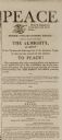
| Date: | 02 13 1815 |
|---|---|
| Description: | Newspaper article declaring peace between the United States and Great Britain at the end of the War of 1812. |
If you didn't find the material you searched for, our Library Reference Staff can help.
Call our reference desk at 608-264-6535 or email us at: