 Filter: Categories of Wisconsin Historical Images
Filter: State of New York
Filter: Subject of mountains
Filter: Categories of Wisconsin Historical Images
Filter: State of New York
Filter: Subject of mountains
| Date: | 1895 |
|---|---|
| Description: | Cover of a German language advertising catalog for the Johnston Harvester Company. The cover features a color chromolithograph illustration of a farmer ope... |

| Date: | |
|---|---|
| Description: | View of a winding path with metal handrails leading up the side of a mountain to a fire lookout tower. |
| Date: | |
|---|---|
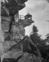
| Description: | A small shelter built on overhanging rock in the mountains. |

| Date: | |
|---|---|
| Description: | View of the Whiteface Mountain Highway Toll Station, and three cars parked nearby. |

| Date: | |
|---|---|
| Description: | A man and woman relaxing in the Adirondack Mountains in New York State. The woman is holding a cat, and a dog is curled up near her feet. |

| Date: | |
|---|---|
| Description: | A view of a camp of the Catskill Aqueduct workers including three men, three women, and one child. Caption reads: "Camp of Catskill Aqueduct Workers, Pleas... |
| Date: | |
|---|---|
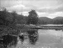
| Description: | Girls canoe near a dock at Camp Lenoloc as additional girls watch from the shoreline. Trees and other foliage line the water and mountains are in the backg... |
| Date: | |
|---|---|
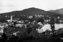
| Description: | View of Mount Baker, overlooking the small town near the bay. |
| Date: | 1882 |
|---|---|
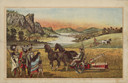
| Description: | Back cover of catalog with an illustration of two men using horse-drawn agricultural machinery in fields, while a group of Native American Indians look on.... |

| Date: | 10 19 1933 |
|---|---|
| Description: | "A Night Above the Clouds" dinner menu, with a tipped-in infra-red photograph of the peaks around Mt. Everest on cream stock embedded with silver flecks. O... |

| Date: | 1780 |
|---|---|
| Description: | Map of New York and parts of the neighboring states. It shows cities, forts, towns, roads, mountains, lakes, and rivers. several different boundary lines a... |

| Date: | 1795 |
|---|---|
| Description: | Detailed map of New York, showing counties, cities, mines, mills, roads, swamps, mountains, lakes and rivers. The map also shows Native American towns and ... |

| Date: | 1778 |
|---|---|
| Description: | Map of the land between Fort Ticonderoga and Albany. It shows cities, forts, mills, roads, mountains, swamps, waterfalls, lakes, and rivers. A few annotati... |

| Date: | 10 1776 |
|---|---|
| Description: | Broadside map showing the British invasion of New York city in August and September of 1776. The map shows important cities, forts, roads, hills, mountains... |
If you didn't find the material you searched for, our Library Reference Staff can help.
Call our reference desk at 608-264-6535 or email us at: