 Filter: Categories of Wisconsin Historical Images
Filter: State of New York
Filter: Subject of bays
Filter: Categories of Wisconsin Historical Images
Filter: State of New York
Filter: Subject of bays
| Date: | |
|---|---|
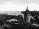
| Description: | Elevated view of a round stone tower and a small stone courtyard on the bay in the Thousand Islands. |
| Date: | |
|---|---|
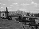
| Description: | A view of artillery and guns at Fort Jay, built in 1794 to defend Upper New York Bay. The New York cityscape is across the bay. |

| Date: | 10 1776 |
|---|---|
| Description: | Broadside map showing the British invasion of New York city in August and September of 1776. The map shows important cities, forts, roads, hills, mountains... |

| Date: | 11 1781 |
|---|---|
| Description: | Map of New York, Staten Island, and Long Island, showing the placements of forts, and the movement of troops in 1776. The map also includes towns, cities, ... |

| Date: | 1923 |
|---|---|
| Description: | Color map of the "Interborough Rapid Transit System of Greater New York". |
If you didn't find the material you searched for, our Library Reference Staff can help.
Call our reference desk at 608-264-6535 or email us at: