 Filter: Categories of Wisconsin Historical Images
Filter: State of Michigan
Filter: Year of 1800-1899
Filter: Subject of water
Filter: Categories of Wisconsin Historical Images
Filter: State of Michigan
Filter: Year of 1800-1899
Filter: Subject of water

| Date: | 1821 |
|---|---|
| Description: | Engraving of the Pictured Rocks shoreline viewed from Lake Superior. |

| Date: | 1821 |
|---|---|
| Description: | Engraving depicting the Schoolcraft expedition crossing the Ontonagon River to investigate a copper boulder. |
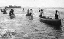
| Date: | 07 16 1898 |
|---|---|
| Description: | A group of Ojibwa men fishing from boats. |
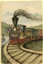
| Date: | 1857 |
|---|---|
| Description: | At the opening of the railway between Grandhaven and Grand Rapids, Michigan on July 26, 1857, the locomotive Grand Rapids was manned by the railroad... |
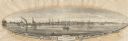
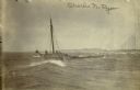
| Date: | 1855 |
|---|---|
| Description: | View of Detroit with several boats and ships in (probably) the Detroit River. |
| Date: | 07 30 1865 |
|---|---|
| Description: | An exterior view across water of Robert Stephenson & Company Mill, which was a steam mill. |

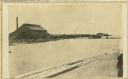
| Date: | 1887 |
|---|---|
| Description: | The Ramsay & Jones Mill with logs in the water in the foreground. |
| Date: | 04 18 1897 |
|---|---|
| Description: | Schooner Charles N. Ryan wrecked in a storm north of Ludington, Michigan on April 18, 1897. Possibly a photograph of the crew being rescued by the L... |

| Date: | 1836 |
|---|---|
| Description: | This map shows Havre Bay, a part of Maumee Bay, parts of Indian Island, Gard’s Island (Michigan), the Ottawa River, Vance River, creeks, and Ottawa Point (... |

| Date: | 1858 |
|---|---|
| Description: | This map shows the depth of the West Channel and the different types of minerals that make up the floor bed. The steamboat range station is labeled. A note... |

| Date: | 1893 |
|---|---|
| Description: | This map shows the depths of the East Neebish Rapids and the different types of minerals that make up the floor bed. Islands and Canada West is labeled. No... |

| Date: | 1851 |
|---|---|
| Description: | This map shows townships, villages, Indian villages, railroads, roads, mills, prairies, swamps, and canals. An inset map shows a plat of the copper distric... |

| Date: | 1864 |
|---|---|
| Description: | This map shows land owners, buildings, cities and villages, lakes, rivers, and roads. The margins include inset maps: Berlin; Mill Point; Holland; Ferrisvi... |
If you didn't find the material you searched for, our Library Reference Staff can help.
Call our reference desk at 608-264-6535 or email us at:
