 Filter: Categories of Wisconsin Historical Images
Filter: State of Maryland
Filter: Subject of land
Filter: Categories of Wisconsin Historical Images
Filter: State of Maryland
Filter: Subject of land
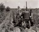
| Date: | 1942 |
|---|---|
| Description: | 16-year-old Wanda Lee Grace, a participant in "Tractorette" class offered by the Nodaway County Implement Company, driving her father's Farmall B tractor t... |
| Date: | 1900 |
|---|---|
| Description: | Elevated view of a man with two mules on the left pulling a boat up the Chesapeake and Ohio Canal. A large wooden building is on the right bank in the behi... |

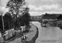
| Date: | 1905 |
|---|---|
| Description: | Elevated view of National Pike, on the west side of Martin's Mountain. The pike is a winding dirt road proceeding up a hill, surrounded by a fence and tele... |

| Date: | |
|---|---|
| Description: | Side view of the church across a yard with trees and plants. The side of the church has stained glass windows. In the foreground on the right is a wooden s... |

| Date: | 1946 |
|---|---|
| Description: | Man driving International truck with semi-trailer owned and operated by Davidson Fast Freight, a division of Davidson Transfer & Storage Company. |

| Date: | 08 1892 |
|---|---|
| Description: | Engraving, probably after a photograph, showing Frank Lenz posing with his safety bicycle near the stone arch entrance of a canal tunnel cut through a moun... |
| Date: | 1900 |
|---|---|
| Description: | View across road towards stone walls, with a gate, which run along the road, and through a field towards the left. A man is using a horse-drawn plow in the... |
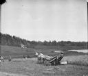
| Date: | 1900 |
|---|---|
| Description: | Men are working in a field near a man using a horse-drawn McCormick binder. People are watching at the edge of the field in the background. On a hill above... |

| Date: | 1940 |
|---|---|
| Description: | Left side view of a man driving a Farmall H tractor with disk harrow in a field. Shocks of corn are in long rows in the field. Farm buildings are in the fa... |

| Date: | 1719 |
|---|---|
| Description: | Map of Maryland and surrounding states. It shows the boundaries, counties, cities, towns, rivers, and bays. Mountains, forests, and swamps appear pictoria... |

| Date: | 1778 |
|---|---|
| Description: | Detailed map of the Chesapeake Bay region and surrounding states. It shows a detailed account of the borders, cities, towns, islands, swamps, mountains, ri... |
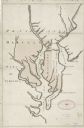
| Date: | 1732 |
|---|---|
| Description: | Map showing the the Chesapeake and Delaware Bay and surrounding land, including the rivers which drain into the bays. The border of Maryland and Delaware i... |

| Date: | 1780 |
|---|---|
| Description: | Map of Maryland and a portion of the surrounding provinces. It shows the boundary lines and borders, counties, cities, towns, roads, mountains, bays, and r... |
If you didn't find the material you searched for, our Library Reference Staff can help.
Call our reference desk at 608-264-6535 or email us at: