 Filter: Categories of Wisconsin Historical Images
Filter: State of Louisiana
Filter: Subject of rivers
Filter: Categories of Wisconsin Historical Images
Filter: State of Louisiana
Filter: Subject of rivers

| Date: | 1864 |
|---|---|
| Description: | This map shows pictorially a section of bracketdam, section of tree dam, and crib of stone. This map was prepared by order of General Joseph Bailey and is ... |
| Date: | |
|---|---|
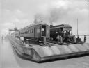
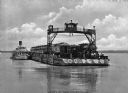
| Description: | View of Southern Pacific Railroad cars being transferred across the Mississippi River with a barge near New Orleans. |
| Date: | 02 28 1863 |
|---|---|
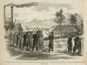
| Description: | The First Regiment of the Louisiana Native Guards disembarking at Fort Macomb, Louisiana. The fort is adjacent to the Venetian Isles community, now legally... |
| Date: | |
|---|---|
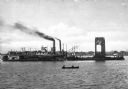
| Description: | A floating span of Southern Pacific Railroad Bridge over the Atchatalaya River under construction. A steamboat is pulling the bridge section on a raft and ... |
| Date: | |
|---|---|
| Description: | A fleet of steamboats used by General Joseph Bailey of the Fourth Wisconsin Cavalry constructing a bridge across the Atchafalaya passage of General Banks' ... |
| Date: | |
|---|---|
| Description: | View of a barge transporting railroad cars and an engine across a river. Several men are on the barge, including one on an overhead structure. Text on phot... |
| Date: | |
|---|---|
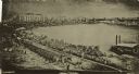
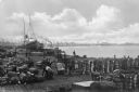
| Description: | Elevated view of a dock scene, where workers are preparing bales of cotton for loading. A steamship and a tugboat are nearby. More ships and the shoreline ... |
| Date: | |
|---|---|
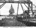
| Description: | View of several men unloading a barge of sugar cane with a crane-like tool. A river and dock area are in the background. Caption reads: "Unloading Sugar Ca... |
| Date: | 1920 |
|---|---|
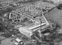
| Description: | Aerial view of the Baldwin Lumber Company, which sits next to a river. The main building consists of two long, rectangular structures that sit perpendicula... |

| Date: | |
|---|---|
| Description: | View of railroad cars being ferried across the river. |

| Date: | 1761 |
|---|---|
| Description: | Map covering southern Louisiana from Lake Ponchetrain to the Golf of Mexico and from Woods Bay in the west to the islands just east of Bay St. Louis. It sh... |

| Date: | 1759 |
|---|---|
| Description: | Map of New Orleans at the start of the French & Indian War, including two inset maps entitled "The Course of the Mississipi River from Bayagoulas to the Se... |

| Date: | 1769 |
|---|---|
| Description: | Map of New Orleans at the start of the French & Indian War, including two inset maps of the Mississippi River Delta and Fort la Balise. It shows streets, r... |

| Date: | 1761 |
|---|---|
| Description: | Map of New Orleans with north oriented towards the upper right corner. It shows the land around the city, the Mississippi River, anchorages, roads leading ... |
If you didn't find the material you searched for, our Library Reference Staff can help.
Call our reference desk at 608-264-6535 or email us at: