 Filter: Categories of Wisconsin Historical Images
Filter: State of Louisiana
Filter: Type of Map or Atlas
Filter: Categories of Wisconsin Historical Images
Filter: State of Louisiana
Filter: Type of Map or Atlas

| Date: | 1864 |
|---|---|
| Description: | This map shows pictorially a section of bracketdam, section of tree dam, and crib of stone. This map was prepared by order of General Joseph Bailey and is ... |
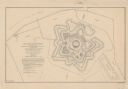
| Date: | 1862 |
|---|---|
| Description: | This detailed plan of Fort Jackson, in Plaquemines Parish, Louisiana, indicates the damage inflicted by the April, 1862, bombardment of the fort by Union f... |

| Date: | 1761 |
|---|---|
| Description: | Map covering southern Louisiana from Lake Ponchetrain to the Golf of Mexico and from Woods Bay in the west to the islands just east of Bay St. Louis. It sh... |

| Date: | 1759 |
|---|---|
| Description: | Map of New Orleans at the start of the French & Indian War, including two inset maps entitled "The Course of the Mississipi River from Bayagoulas to the Se... |

| Date: | 1769 |
|---|---|
| Description: | Map of New Orleans at the start of the French & Indian War, including two inset maps of the Mississippi River Delta and Fort la Balise. It shows streets, r... |

| Date: | 1761 |
|---|---|
| Description: | Map of New Orleans with north oriented towards the upper right corner. It shows the land around the city, the Mississippi River, anchorages, roads leading ... |
If you didn't find the material you searched for, our Library Reference Staff can help.
Call our reference desk at 608-264-6535 or email us at: