Filter: Categories of Wisconsin Historical Images
Filter: State of Kentucky
Filter: Year of 1800-1899
Filter: Subject of water
Filter: Categories of Wisconsin Historical Images
Filter: State of Kentucky
Filter: Year of 1800-1899
Filter: Subject of water

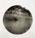
| Date: | 1862 |
|---|---|
| Description: | Sketch of Boone's Knob and the Kentucky River, where Company A of the 22nd Wisconsin Infantry camped, November-December, 1862. The sketch was drawn by Priv... |
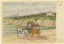
| Date: | 1858 |
|---|---|
| Description: | Hölzlhuber journeyed from Chicago to Louisville, Kentucky, and from there took a train south to Cave City, from which passengers boarded a stagecoach for t... |
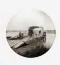
| Date: | 05 26 1894 |
|---|---|
| Description: | A ferryman poses on his docked ferry. Two horses are loaded on the ferry. |
| Date: | 05 26 1894 |
|---|---|
| Description: | William and Fred pose at the edge of a pond or creek. |

| Date: | 05 27 1894 |
|---|---|
| Description: | A small crowd of men and boys in hats on the shoreline seeing the Thwaites family off at the Indian Kentucky River. |

| Date: | 05 29 1894 |
|---|---|
| Description: | A crowd of people gathered on a wharf with boats in the foreground. |

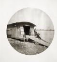
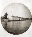
| Date: | 05 30 1894 |
|---|---|
| Description: | A houseboat on the Ohio River. A man stands on the deck of the boat on the right. |
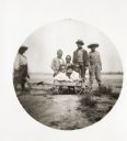
| Date: | 06 02 1894 |
|---|---|
| Description: | A group of children pose with a small cart. |
| Date: | 06 04 1894 |
|---|---|
| Description: | View of a church boat called "Bethel" on the river. |
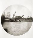
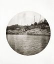
| Date: | 06 04 1894 |
|---|---|
| Description: | A fleet of dredges moored to the Kentucky shore. |
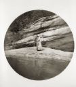
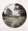
| Date: | 06 08 1894 |
|---|---|
| Description: | A man and woman fish at the base of a large rock formation. |

| Date: | 11 26 1883 |
|---|---|
| Description: | A hand-drawn map of the Clinch and Powell's Valleys, including the Cumberland Mountains, Powell's Mountains and Clinch Mountains. |

| Date: | 1847 |
|---|---|
| Description: | A color map of Kentucky with insets showing Lexington, the Falls of Ohio, and the Ohio River. |

| Date: | 1831 |
|---|---|
| Description: | Map of the city of Louisville, Kentucky on the Ohio River showing streets and numbered lots. The Ohio River, Corn Island, and the Louisville and Portland C... |

| Date: | 1828 |
|---|---|
| Description: | Map of the Louisville and Portland Canal on the Ohio River. The map shows Louisville, Shippingsport, Clarksville, Jeffersonville, Gravel Island, Corn Islan... |
If you didn't find the material you searched for, our Library Reference Staff can help.
Call our reference desk at 608-264-6535 or email us at: