 Filter: Categories of Wisconsin Historical Images
Filter: GENRE of Manuscript
Filter: Subject of maps
Filter: Categories of Wisconsin Historical Images
Filter: GENRE of Manuscript
Filter: Subject of maps
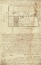
| Date: | 01 12 1844 |
|---|---|
| Description: | Letter from Thomas Steel, Waukesha County physician and farmer, to his father, James Steel, in London, England. It includes a hand-drawn map of Milwaukee C... |
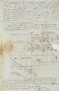
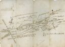
| Date: | 11 26 1846 |
|---|---|
| Description: | A drawing by Thomas Steel of his farm property contained in a letter Steel wrote to his father James Steel. |
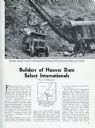
| Date: | 03 1932 |
|---|---|
| Description: | Page from International Trail magazine featuring an article about the use of International trucks for the construction of the Hoover Dam. The title ... |
| Date: | 07 04 1776 |
|---|---|
| Description: | Notes written in red ink on the back of the map of the Battle of Black's Fort. |
| Date: | 08 1861 |
|---|---|
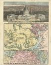
| Description: | Large-format, illustrated stationery purchased by Rudolph Fine, a member of the 6th Wisconsin Infantry in August, 1861, showing the Capitol (in actuality, ... |
| Date: | 1979 |
|---|---|
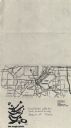
| Description: | Map for location of the Magic Picnic, a celebration of the lesbian and gay community, which took place in Brittingham Park. |
| Date: | 1979 |
|---|---|
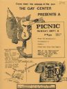
| Description: | Poster for picnic presented by the Gay Center at Vilas Park. Includes an image of a fox and telephone. |
| Date: | 1890 |
|---|---|
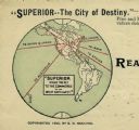
| Description: | Letterhead for Moulton, Moran & Co. The logo shows North America and depicts Superior as the center of a hub with spokes going to Russia, to China and Japa... |
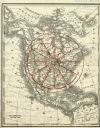
| Date: | 1890 |
|---|---|
| Description: | Rand, McNally map of North America enhanced to show Superior as the center of a wheel. The image was used on the back of stationery from City Improvement C... |
| Date: | |
|---|---|
| Description: | Hand-drawn map including the Clinch River and Clinch mountain range. The Clinch River rises in Southwest Virginia near Tazewell, VA and flows southwest thr... |
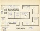
| Date: | 03 24 1964 |
|---|---|
| Description: | Floor plan of the Exhibition Hall of the Wisconsin Pavilion at the 1964 World's Fair. Plan shows tentative locations for exhibits by Aqua Chem, Pruden, Ham... |
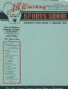
| Date: | 1947 |
|---|---|
| Description: | Letterhead of the All Wisconsin Sports Show, presented by the Madison Business Association, with an outline map of the state and a star marking the locatio... |
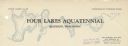
| Date: | |
|---|---|
| Description: | Letterhead of the Four Lakes Aquatennial, sponsored by the Four Lakes Club and the Veterans of Foreign Wars, with a background illustration of the chain of... |
| Date: | 1974 |
|---|---|
| Description: | Flyer advertising a May Day rally in support of public workers to be held at Library Mall on the University of Wisconsin-Madison campus. Local public worke... |

| Date: | 01 13 1937 |
|---|---|
| Description: | Sketch map of Township 7 North, Range 9 East, created for the Land Economic Inventory (Bordner Survey). The map shows Picnic Point and the Lake Mendota sho... |
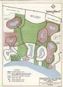
| Date: | 03 28 1964 |
|---|---|
| Description: | A master plan and land use map for East Lake Wales in Polk County, Florida showing where industrial sites, a shopping and civic center, golf course, marina... |
If you didn't find the material you searched for, our Library Reference Staff can help.
Call our reference desk at 608-264-6535 or email us at: