 Filter: Categories of Wisconsin Historical Images
Filter: Year of 1700-1799
Filter: Year of 1770-1779
Filter: Categories of Wisconsin Historical Images
Filter: Year of 1700-1799
Filter: Year of 1770-1779
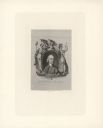
| Date: | 1774 |
|---|---|
| Description: | Engraved portrait of Samuel Adams, a Founding Father of the United States and 4th Governor of Massachusetts (1792-1794). Adams' portrait is framed in an ov... |
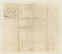
| Date: | 06 22 1774 |
|---|---|
| Description: | The address page of a letter written by Col. William Christian to Col. William Preston. There is a note on the right side: "Surveyors out. Suggests sending... |
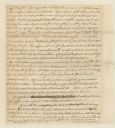
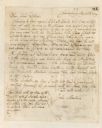
| Date: | 06 21 1774 |
|---|---|
| Description: | Page two of a letter written by William Christian to Col. William Preston. From Preston and Virginia Papers [Calendar series Volume 1]: "Dunkard Bot... |
| Date: | 04 24 1779 |
|---|---|
| Description: | A statement written by William Preston. From Preston and Virginia Papers [Calendar series Volume 1]: "Statement acquitting George Patterson of the c... |
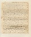
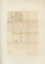
| Date: | 06 20 1774 |
|---|---|
| Description: | Page one of a letter written by William Christian to Col. William Preston. From Preston and Virginia Papers [Calendar series Volume 1]: "Dunkard Bot... |
| Date: | 06 22 1774 |
|---|---|
| Description: | The back of a one page letter written from New Dublin by William Christian to Col. William Preston. |
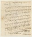
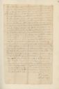
| Date: | 06 22 1774 |
|---|---|
| Description: | A letter from New Dublin written by William Christian to Col. William Preston. |
| Date: | 05 28 1779 |
|---|---|
| Description: | Letter written by John Monture to John Dodge. |

| Date: | 1775 |
|---|---|
| Description: | Map of Boston and surrounding regions, from Massachusetts Bay to the Connecticut River, and including part of southern New Hampshire. It shows the colonies... |

| Date: | 1777 |
|---|---|
| Description: | Map of Colonial America east of Lake Michigan showing regions, cities, forts, Native American land, mountains, lakes, and rivers. Crossed swords and small ... |
| Date: | 1776 |
|---|---|
| Description: | Map of the Kenebec and Chaudiere River from the Atlantic Ocean to the Saint Lawrence River. Cities, forts, lakes, and tributaries along the two rivers are ... |

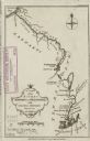
| Date: | 1776 |
|---|---|
| Description: | Map showing New England, Nova Scotia, and Newfoundland, based on the seminal work of D' Anville, as well as the works of Belllin and de Vaugondy. It shows ... |

| Date: | 1770 |
|---|---|
| Description: | Map of North America showing the boundaries between French, Spanish, and English claims after the French and Indian War. Kitchin includes numerous place na... |

| Date: | 1775 |
|---|---|
| Description: | This six sheet large format map is one of the most informative maps of its time. It shows cities, Native American land, lakes, rivers, mountains, topograph... |

| Date: | 1777 |
|---|---|
| Description: | Map showing the Hudson River in three sections, from New York City up through Lake Champlain, including cities, forts, roads, topographical features, and n... |

| Date: | 1778 |
|---|---|
| Description: | Map of European claims in North America, with France shown as having claim to the most land, and the British colonies confined to east of the Appalacian Mo... |

| Date: | 1776 |
|---|---|
| Description: | Map of the American colonies and land east of the Mississippi River. Prominent cities, forts, Native American land, mountains, rivers and lakes are all sho... |

| Date: | 1777 |
|---|---|
| Description: | This important map highlights the frantic desire and search for the north west passage. It shows a few settlements and mountains in Russia, north west Amer... |

| Date: | 1776 |
|---|---|
| Description: | Map of North America east of Mexico showing important cities, the colonies, regions, Native American land, mountains, lakes, and rivers. A series of lakes,... |
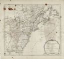
| Date: | 1775 |
|---|---|
| Description: | Map showing the American colonies on the eve of the Revolutionary War. Cities, boundaries, regions, forts, Native American lands, mountains, lakes, and riv... |
If you didn't find the material you searched for, our Library Reference Staff can help.
Call our reference desk at 608-264-6535 or email us at: