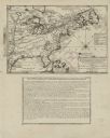
| Date: | 1700 |
|---|---|
| Description: | Map of the British colonies in North America at the beginning of the eighteenth century. It includes five inset maps of Nova Scotia, Jamaica, Bermuda, Barb... |

| Date: | 1705 |
|---|---|
| Description: | Map of America east of the Mississippi River showing boundaries, rivers, portages, forts, cities, villages, and Native American land. Annotations on early ... |

| Date: | 1703 |
|---|---|
| Description: | Map of the Golf of Mexico and surrounding countries from the Great Lakes down to the northern most parts of South America. L'Isle labels cities, towns, and... |

| Date: | 1700 |
|---|---|
| Description: | Map of the western hemisphere showing settelments, coastal features, islands, rivers, lakes, and pictoral representations of forests and mountains. The Gre... |

| Date: | 1709 |
|---|---|
| Description: | Map of North America, showing a few of the largest settlements, regions, islands, and a few rivers. The Great Lakes are depicted, but over-sized, and Calif... |
If you didn't find the material you searched for, our Library Reference Staff can help.
Call our reference desk at 608-264-6535 or email us at: