 Filter: Categories of Wisconsin Historical Images
Filter: Subject of water
Filter: Subject of military camps
Filter: Categories of Wisconsin Historical Images
Filter: Subject of water
Filter: Subject of military camps
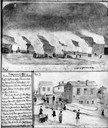
| Date: | 11 08 1906 |
|---|---|
| Description: | Two Civil War watercolor drawings by John Gaddis, Company E, 12th Wisconsin Volunteer Infantry, showing the regiment in bivouac, and later their headquarte... |

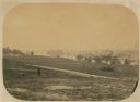
| Date: | 1876 |
|---|---|
| Description: | Quite possibly this is the "View of Capt. L.M. Lange's tent and seven Captains" listed in the "Centennial Views of the City of Madison, July 4th, 1876. Vie... |
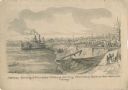
| Date: | 05 1862 |
|---|---|
| Description: | "Hamburg Landing, 4 miles below Pittsburg Landing, Commisary [sic] Depot of Gen. Hallek's Army." An encampment with soldiers along the river with a ... |
| Date: | 06 1862 |
|---|---|
| Description: | The 7th Wisconsin Volunteer Infantry Regiment camp outside of Fredericksburg on the east side of the Rappahannock. Fredericksburg and a pontoon bridge lea... |

| Date: | 1816 |
|---|---|
| Description: | This is a photostat copy of a manuscript map in the National Archives showing a plan of Fort Howard and a view of its north side. Originally surveyed by Wi... |

| Date: | 1912 |
|---|---|
| Description: | This map from the U.S. General Land Office shows railroads, counties, cities and villages, rivers, lakes, U.S. Land Offices, Indian reservations, military ... |

| Date: | 1931 |
|---|---|
| Description: | A topographical map from the U.S. Army Corp of Engineers showing the topography and man-made features in the Camp Williams area of the towns of Orange and ... |
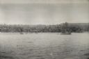
| Date: | 08 11 1943 |
|---|---|
| Description: | A view of Milne Bay, New Guinea (present day Papua New Guinea), from the sea. A ship can be seen on the right, at the shoreline. |
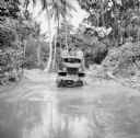
| Date: | 08 15 1943 |
|---|---|
| Description: | Three soldiers in a truck drive through mud on Kiriwina Island in the Solomon Sea, New Guinea (present day Papua New Guinea). Jungle foliage is in the back... |

| Date: | 08 24 1943 |
|---|---|
| Description: | An indigenous woman wearing a grass shirt sits on a carved boat with Robert Doyle on the shore of Kiriwina Island in the Solomon Sea, New Guinea (present d... |

| Date: | 10 24 1943 |
|---|---|
| Description: | Robert Doyle's caption says it best, "The ol' swimmin' hole, South Pacific style. Every afternoon it is filled with shouting soldiers in their birthday sui... |
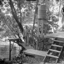
| Date: | 01 11 1944 |
|---|---|
| Description: | A soldier is standing on the ramp leading to the camp toilet suspended over the water, with a roll of toilet paper sitting on the edge. On the right is a w... |
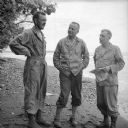
| Date: | 02 03 1944 |
|---|---|
| Description: | Wisconsin artillery officers helping direct the shelling of the Japanese on Saidor's west flank (beyond the point in the background). The officers are, (le... |
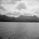
| Date: | 1942 |
|---|---|
| Description: | View over water towards the New Guinea coast from a boat. A larger boat is on the right and several smaller craft in the center. A pier is on the shoreline... |

| Date: | 10 24 1943 |
|---|---|
| Description: | Robert Doyle's caption for Image ID: 99742 says it best, "The ol' swimmin' hole, South Pacific style. Every afternoon it is filled with shouting soldiers i... |
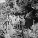
| Date: | 10 24 1943 |
|---|---|
| Description: | Three officers of General Walter Krueger's staff stand on a log in front of a swimming hole located on Goodenough Island, in the Solomon Sea, New Guinea (p... |

| Date: | |
|---|---|
| Description: | A hand-drawn map of Camp Curtis which was prepared for Colonel R. McMurphy. |

| Date: | 1900 |
|---|---|
| Description: | This map shows portion of the military road from Fond du Lac to the Wisconsin River near Fort Winnebago, with mile markers and adjacent land use. A few pro... |

| Date: | 10 1776 |
|---|---|
| Description: | Broadside map showing the British invasion of New York city in August and September of 1776. The map shows important cities, forts, roads, hills, mountains... |

| Date: | 02 1777 |
|---|---|
| Description: | Map depicting the campaigns of October and November 1776, in Manhattan, Westchester, and part of New Jersey, published only a few months after the conclusi... |
If you didn't find the material you searched for, our Library Reference Staff can help.
Call our reference desk at 608-264-6535 or email us at: