 Filter: Categories of Wisconsin Historical Images
Filter: Subject of political science
Filter: Year of 1700-1799
Filter: Year of 1770-1779
Filter: Categories of Wisconsin Historical Images
Filter: Subject of political science
Filter: Year of 1700-1799
Filter: Year of 1770-1779

| Date: | 1772 |
|---|---|
| Description: | Scale: about 180 miles to 1 in. |
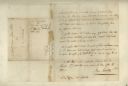
| Date: | 02 24 1779 |
|---|---|
| Description: | A letter from Governor Henry Hamilton to Colonel Clark proposing a truce. |

| Date: | 1770 |
|---|---|
| Description: | Map of North America from the Great Lakes to the northern portion of South America. It shows cities, Native American land, mountains, swamps, lakes, rivers... |

| Date: | 1776 |
|---|---|
| Description: | Map showing the English claims in America at the outbreak of the Revolutionary War. Lotter labels each of the thirteen colonies (both in the map and in the... |

| Date: | 1778 |
|---|---|
| Description: | Map of European claims in North America, with France shown as having claim to the most land, and the British colonies confined to east of the Appalacian Mo... |

| Date: | 1770 |
|---|---|
| Description: | Map of North America showing the boundaries between French, Spanish, and English claims after the French and Indian War. Kitchin includes numerous place na... |

| Date: | 1777 |
|---|---|
| Description: | Map of Colonial America east of Lake Michigan showing regions, cities, forts, Native American land, mountains, lakes, and rivers. Crossed swords and small ... |
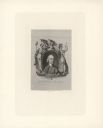
| Date: | 1774 |
|---|---|
| Description: | Engraved portrait of Samuel Adams, a Founding Father of the United States and 4th Governor of Massachusetts (1792-1794). Adams' portrait is framed in an ov... |
If you didn't find the material you searched for, our Library Reference Staff can help.
Call our reference desk at 608-264-6535 or email us at: