 Filter: Categories of Wisconsin Historical Images
Filter: Subject of political science
Filter: Subject of clothing and dress
Filter: Year of 1700-1799
Filter: Categories of Wisconsin Historical Images
Filter: Subject of political science
Filter: Subject of clothing and dress
Filter: Year of 1700-1799
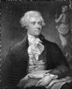
| Date: | 1786 |
|---|---|
| Description: | Portrait engraving of Thomas Jefferson, from the painting by M. Brown. |

| Date: | 1712 |
|---|---|
| Description: | Engraved double-hemispherical world map by Moll, included in his atlas The world described, or, A new and correct sett of maps: shewing the kingdoms and st... |

| Date: | 1740 |
|---|---|
| Description: | Engraved and hand-colored map of the Iberian peninsula as a theater of war during the War of the Spanish Succession (1701-1714). The map is dedicated to Ki... |

| Date: | 1780 |
|---|---|
| Description: | Map of North and South America, showing the boundaries of colonial territories, cities, settlements, rivers, lakes, and Native American land. Particular em... |

| Date: | 1710 |
|---|---|
| Description: | Map of North America showing the European claims, Native American land and villages, rivers, lakes, cities, and notes on explorers, discoveries, and topogr... |

| Date: | 1719 |
|---|---|
| Description: | Map of North America showing land divisions between France, Spain, England, Sweden, Denmark and Holland. The map is detailed, labeling cities, forts, islan... |

| Date: | 1770 |
|---|---|
| Description: | Map of North America from the Great Lakes to the northern portion of South America. It shows cities, Native American land, mountains, swamps, lakes, rivers... |
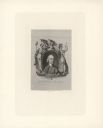
| Date: | 1774 |
|---|---|
| Description: | Engraved portrait of Samuel Adams, a Founding Father of the United States and 4th Governor of Massachusetts (1792-1794). Adams' portrait is framed in an ov... |
If you didn't find the material you searched for, our Library Reference Staff can help.
Call our reference desk at 608-264-6535 or email us at: