 Filter: Categories of Wisconsin Historical Images
Filter: Subject of political science
Filter: Type of Map or Atlas
Filter: Creator Name of Unknown
Filter: Categories of Wisconsin Historical Images
Filter: Subject of political science
Filter: Type of Map or Atlas
Filter: Creator Name of Unknown

| Date: | 1889 |
|---|---|
| Description: | Illustration of the exterior of the Fuller Opera House, which is a detail from a bird's-eye view map of Madison. |
| Date: | |
|---|---|
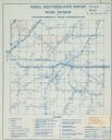
| Description: | Rural electrification map of Dodge county in Elba township. Title at top reads: "Rural Electrification Survey by Work Division of Wisconsin Emergency Relie... |
| Date: | 1922 |
|---|---|
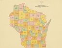
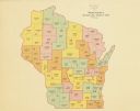
| Description: | A map of Wisconsin showing the state’s Assembly Districts. It also provides the population total of each county. |
| Date: | 1922 |
|---|---|
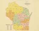
| Description: | A map of Wisconsin showing the state’s congressional districts, it also provides the population total for the state, each district and each county. |
| Date: | 1922 |
|---|---|
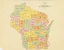
| Description: | A map of Wisconsin showing the state’s Senate districts, it also provides the population total for each county. |
| Date: | 1922 |
|---|---|
| Description: | A map of Wisconsin showing the state’s judicial districts, it also provides the population total for each county. |

| Date: | 1898 |
|---|---|
| Description: | A hand-colored, cloth mounted map of Wisconsin showing the state’s congressional districts. The map also shows the counties, cities, towns, villages, river... |

| Date: | 1961 |
|---|---|
| Description: | Shows wards and voting precincts. Published in The Capital times: January 28, 1961. |

| Date: | 1964 |
|---|---|
| Description: | A simple map of the Mississippi Project. There are symbols at the bottom marking locations for: Voter Registration, Freedom School, Community Center and Pr... |

| Date: | 1960 |
|---|---|
| Description: | A hand-drawn map showing the "Negro Percentage of Each County's Population" in Mississippi. |

| Date: | 1939 |
|---|---|
| Description: | This is a zoning map of Wauwatosa with a key of districts including agricultural, resident, business, commercial, and industrial. The map features labeled ... |

| Date: | 1965 |
|---|---|
| Description: | This map shows wards, city limits, railroad right of way, proposed future streets, and approximate street elevations. Wards and public schools are labeled ... |

| Date: | 1782 |
|---|---|
| Description: | Map of the West Indies and south eastern North America, remarkably detailed, showing cities, mountains, rivers, lakes, mines, plantations, forts, banks, an... |

| Date: | 1763 |
|---|---|
| Description: | Map of America and part of Canada including the borders of European claims after the French and Indian War. Cities, forts, Native American lands, rivers, l... |

| Date: | 1853 |
|---|---|
| Description: | A map of Wellfleet Harbor on Cape Cod Bay. |

| Date: | |
|---|---|
| Description: | In 1935, 202 families from the northern regions of Michigan, Wisconsin, and Minnesota were selected for this resettlement project, located near Palmer, Ala... |
If you didn't find the material you searched for, our Library Reference Staff can help.
Call our reference desk at 608-264-6535 or email us at: