Filter: Categories of Wisconsin Historical Images
Filter: Subject of persons
Filter: Year of 1600-1699
Filter: Categories of Wisconsin Historical Images
Filter: Subject of persons
Filter: Year of 1600-1699
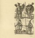
| Date: | 1616 |
|---|---|
| Description: | Illustration of four Algonquian Indians. E depicts a man dressed for combat in wood armor. F shows a woman in her regular dress carrying a child and an ear... |
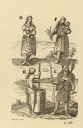
| Date: | 1615 |
|---|---|
| Description: | Drawings of four Native Americans. A and C are dressed for combat. B appears to be a woman carrying and nursing an infant, and D is wearing winter garb, in... |

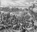
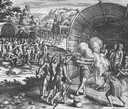
| Date: | 1615 |
|---|---|
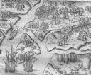
| Description: | Illustration of the Huron Indians and French explorers attacking an Iroquois fort near present day Fenner, New York. A wooden platform was constructed to f... |

| Date: | 1671 |
|---|---|
| Description: | Map of Virginia depicting the discoveries detailed by John Smith in his exploration of the region. It shows Jamestown, Native American tribes and villages,... |

| Date: | 1683 |
|---|---|
| Description: | Map of the north east coast of North America showing islands, regions, Native American land, bays, and a few European settlements. The Great Lakes appear i... |

| Date: | 1684 |
|---|---|
| Description: | Map of North America showing some colonies, cities, rivers, lakes, and Native American land. Ship routes spread across both oceans, including one decorated... |

| Date: | 1676 |
|---|---|
| Description: | Detailed map of North and South America. Cities, towns, forests, and mountains are shown pictorially. Duval labels regions, islands, cities, lakes, and Nat... |

| Date: | 1690 |
|---|---|
| Description: | A mysterious mixture of mythology, ancient geography, and late 17th century knowledge of the American coastline. This map shows North and South America, bu... |

| Date: | 1630 |
|---|---|
| Description: | One of the few maps by Dutch cartographer Willem Blaeu depicting the Americas, this map shows regions, settlements, islands, mountains, forests, rivers, an... |

| Date: | 1627 |
|---|---|
| Description: | Map of North and South America showing settlements, rivers, lakes, mountains, islands and regions of the western hemisphere. It includes an inset map of Gr... |

| Date: | 1696 |
|---|---|
| Description: | Engraved and hand-colored map of Ethiopia, from Blaeu's General Atlas. Map title is framed by a man and a woman, both wearing head turbans, who are standin... |

| Date: | 1625 |
|---|---|
| Description: | An illustrated map of the world with captions in Latin. Illustrations include depictions of the seasons and the elements. |
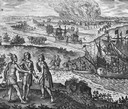
| Date: | 1655 |
|---|---|
| Description: | Scene from the Jamestown Settlement in Virginia, 1607. |
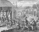
| Date: | 1655 |
|---|---|
| Description: | Scene from Jamestown Settlement in Virginia, 1610. |
| Date: | 1655 |
|---|---|
| Description: | Engraving made after a painting by Jacques Le Moyne de Morgues (died 1588) while on the Laudonnière Expedition in Florida, ca. 1564. |
| Date: | 1655 |
|---|---|
| Description: | Scene from Vespucci Expedition, 1499. |
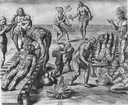
| Date: | 1655 |
|---|---|
| Description: | Girolamo Benzoni (1519-1570) was an Italian from Milan who spent the years 1541-1556 in the New World. His observations of Spanish imperialism were publish... |
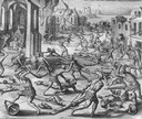
| Date: | 1655 |
|---|---|
| Description: | Scene from the Laudonnière Expedition in South Carolina, ca. 1564. |

| Date: | 1688 |
|---|---|
| Description: | This map includes vignettes of Amerindian life with text describing geography, culture, and exploration activity, written in French. The Great Lakes, river... |
If you didn't find the material you searched for, our Library Reference Staff can help.
Call our reference desk at 608-264-6535 or email us at: