 Filter: Categories of Wisconsin Historical Images
Filter: Subject of persons
Filter: Subject of international relations
Filter: Categories of Wisconsin Historical Images
Filter: Subject of persons
Filter: Subject of international relations

| Date: | 1733 |
|---|---|
| Description: | This map of North America shows settlements, rivers, lakes, Native American land, trade winds, and numerous topographical features such as forests and moun... |

| Date: | 1719 |
|---|---|
| Description: | Map of North America showing land divisions between France, Spain, England, Sweden, Denmark and Holland. The map is detailed, labeling cities, forts, islan... |

| Date: | 1710 |
|---|---|
| Description: | Map of North America showing the European claims, Native American land and villages, rivers, lakes, cities, and notes on explorers, discoveries, and topogr... |

| Date: | 1780 |
|---|---|
| Description: | Map of North and South America, showing the boundaries of colonial territories, cities, settlements, rivers, lakes, and Native American land. Particular em... |

| Date: | 1770 |
|---|---|
| Description: | Map of North America from the Great Lakes to the northern portion of South America. It shows cities, Native American land, mountains, swamps, lakes, rivers... |

| Date: | 1715 |
|---|---|
| Description: | One of Herman Moll's most famous maps, often referred to as The Codfish Map, it shows rivers and portages, cities, Indian villages, wind directions, routes... |

| Date: | 07 1980 |
|---|---|
| Description: | Vel Phillips, on the left, sitting with two other woman at a table. They are all wearing name tags. Other women sit at tables behind them. |
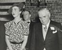
| Date: | 04 24 1939 |
|---|---|
| Description: | Princess Ingrid of Denmark with Wisconsin Governor Julius Heil. The princess is wearing a floral patterned short sleeved dress, a pearl necklace, earrings,... |
| Date: | |
|---|---|
| Description: | Congressman David Obey outdoors in a group of men listening to a speaker in the Middle East. They are surrounded by tents. |

| Date: | 11 15 1989 |
|---|---|
| Description: | Congressman David Obey and Chairman of Solidarity Lech Walesa of Poland shake hands. |
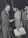
| Date: | 1951 |
|---|---|
| Description: | Arthur J. Altmeyer, President of the Permanent Inter-American Committee on Social Security, greeting Eva Peron, President of the Inter-American Conference ... |
| Date: | 1951 |
|---|---|
| Description: | View of group of people standing on stage at the Inter-American Conference on Social Security. Arthur J. Altmeyer stands in the middle. Eva Peron stands se... |

| Date: | 03 1985 |
|---|---|
| Description: | Arms control talks between visiting Soviets and American legislators. Wisconsin Congressman David R. Obey sat in on the talks with Congressman Tom Downey, ... |
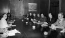
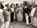
| Date: | 02 1980 |
|---|---|
| Description: | A delegation of congressional leaders meeting with Prime Minister Indira Gandhi of India. They are (right to left) Jack Hightower, Matt McHugh, David R. O... |

| Date: | 1977 |
|---|---|
| Description: | Egyptian President Anwar Sadat and Vice President Hosni Mubarak seated at the far right with a delegation of congressional leaders. Congressman David R. Ob... |
| Date: | 1991 |
|---|---|
| Description: | Wisconsin was well represented on a congressional leadership trip to the Persian Gulf in 1991. Here Congressman David Obey (in plaid shirt) leans over the ... |

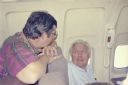
| Date: | 1983 |
|---|---|
| Description: | Wisconsin Congressman David R. Obey (chin in hand) ponders a remark during a meeting of House of Representative leaders with their Soviet equivalents in Mo... |

| Date: | 1980 |
|---|---|
| Description: | Wisconsin Congressman David Obey (center, facing the camera) and other members of the congressional delegation and staff that visited Saudi Arabia and Indi... |

| Date: | 1980 |
|---|---|
| Description: | Wisconsin Congressman David R. Obey (center) studying briefing materials for a diplomatic visit to Pakistan. |
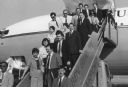
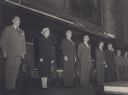
| Date: | 04 1985 |
|---|---|
| Description: | Members of a special House Appropriations Committee mission to the Middle East at the airport in Jerusalem. The committee was headed by Congressman David R... |
If you didn't find the material you searched for, our Library Reference Staff can help.
Call our reference desk at 608-264-6535 or email us at: