 Filter: Categories of Wisconsin Historical Images
Filter: Subject of indians of north america
Filter: Year of 1900-1999
Filter: Year of 1970-1979
Filter: Categories of Wisconsin Historical Images
Filter: Subject of indians of north america
Filter: Year of 1900-1999
Filter: Year of 1970-1979
| Date: | 08 02 1971 |
|---|---|
| Description: | Site of a demonstration by Lac Courte Oreilles Chippewa against the Northern States Power Company dam on the Chippewa Flowage, Sawyer County. There is an A... |
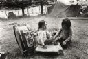
| Date: | 1978 |
|---|---|
| Description: | Native Americans keeping the music alive. George Whitewing, a Ho Chunk musician from Wittenberg, Wisconsin, plays his drum while a crowd looks on in Red Cl... |
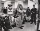
| Date: | 04 26 1971 |
|---|---|
| Description: | Led by James White, president of DRUMS, members of the organization and sympathizers staged a protest Monday at the First Wisconsin National Bank, 743 N. W... |
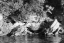
| Date: | 01 07 1973 |
|---|---|
| Description: | The legendary Black Hawk Cave on the south shore of Lake Mendota, where Black Hawk allegedly hid from white troopers during the Black Hawk War. |
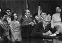
| Date: | 04 22 1975 |
|---|---|
| Description: | Secretary of the Interior Rogers Morton signing the documents that restored tribal status to the Menominee Indians. Watching the ceremony are Senator Gaylo... |
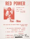
| Date: | 10 05 1970 |
|---|---|
| Description: | Poster for an American Indian Pow-Wow, held at the University of Wisconsin-Madison Stock Pavillion [sic], October 10, including a coalition of nativ... |
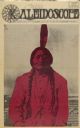
| Date: | 09 14 1970 |
|---|---|
| Description: | Cover of "Kaleidoscope," an underground newspaper, featuring a photograph of Native American Chief Sitting Bull, highlighted with red. |

| Date: | 05 1971 |
|---|---|
| Description: | Poster advertising for a May Day demonstration in Washington, D.C. Features an image of Sitting Bull. |
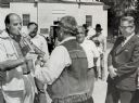
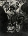
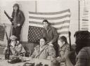
| Date: | 08 1971 |
|---|---|
| Description: | Nelson smokes a peace pipe held by Bill Baker outside a building after a meeting with tribe members. To Nelson's far right is Governor Patrick Lucey, and i... |
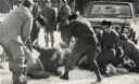
| Date: | 01 27 1975 |
|---|---|
| Description: | Members of the Wisconsin National Guard arrest a group of Native Americans during the takeover of the Alexian Brother Novitiate near Gresham. The arrest wa... |

| Date: | 1975 |
|---|---|
| Description: | Actor Marlon Brando (center) and Father James Groppi of Milwaukee arrive at the Alexian Novitiate in Gresham. The building had been seized by members of th... |
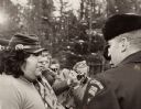
| Date: | 01 18 1975 |
|---|---|
| Description: | Negotiations between leaders of the Menominee Warrior Society and the American Indian Movement with General Hugh Simonson (in the Army jacket) of the Wisco... |
| Date: | 1975 |
|---|---|
| Description: | Negotiations between Neil Hawpetoss, a leader of the Menominee Warrior Society that had seized the Alexian Novitiate at Gresham in January 1975, and a memb... |
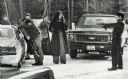
| Date: | 1975 |
|---|---|
| Description: | An unidentified member of the Wisconsin State Patrol points his revolver at several Native Americans at a vehicle checkpoint near Gresham. The State Patrol... |

| Date: | 1979 |
|---|---|
| Description: | A map of Southern Wisconsin and northern Illinois showing the areas inhabited by the Ho-Chuck, formerly known as the Winnebago. Some of the location names ... |

| Date: | 1974 |
|---|---|
| Description: | This 1968 map identifies resorts in the Lac du Flambeau Indian Reservation region of Wisconsin, covering parts of Iron, Vilas, Oneida, and Price counties. ... |

| Date: | 11 26 1970 |
|---|---|
| Description: | A candid portrait of Olivia King in her kitchen at their home on Rabbit Ridge on the Menominee reservation. |

| Date: | 1974 |
|---|---|
| Description: | Map of Wisconsin with drawings illustrating historic places and events throughout the state. The Great Seal of the State of Wisconsin appears at the top ri... |

| Date: | 1975 |
|---|---|
| Description: | This map shows boundaries, roads, national forest land, bogs and wetlands, lakes, campgrounds, and boat landings. |

| Date: | 1970 |
|---|---|
| Description: | This map shows land owned by Menominee Enterprise Inc., land sold to Menominee shareholders, and land sold to non-Menominees. The map also includes water a... |
If you didn't find the material you searched for, our Library Reference Staff can help.
Call our reference desk at 608-264-6535 or email us at: