 Filter: Categories of Wisconsin Historical Images
Filter: Subject of indians of north america
Filter: Subject of trails
Filter: Categories of Wisconsin Historical Images
Filter: Subject of indians of north america
Filter: Subject of trails

| Date: | 1936 |
|---|---|
| Description: | This map is red and black ink on tracing cloth and is oriented with north to the upper left. This hand-drawn map shows a central portion of the military ro... |
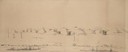
| Date: | 05 1849 |
|---|---|
| Description: | Deserted Pawnee village in Nebraska. Sketched by Wilkins on his 151-day journey from Missouri to California on the Overland Trail (also known as the Oregon... |
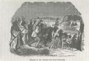
| Date: | |
|---|---|
| Description: | Photograph of an engraving from an unknown source depicting a group of Native American warriors herding white captives along a trail. A building burns in ... |

| Date: | 05 05 1939 |
|---|---|
| Description: | Charles E. Brown poses near a historic tablet marking one of a row of conical burial mounds on the Park and Pleasure drive on the north shore of Lake Wingr... |

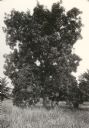
| Date: | 1920 |
|---|---|
| Description: | View of a supposed Indian "trail tree," on former Mercer's addition or subdivision, now the corner of Elm and Van Hise Streets near Madison West High Schoo... |
| Date: | 1920 |
|---|---|
| Description: | View of a supposed Indian "trail tree," on former Mercer's addition or subdivision, now the corner of Chestnut and Van Hise Streets, near Madison West High... |

| Date: | 1920 |
|---|---|
| Description: | View of a supposed Indian "trail tree" on former Mercer's addition or subdivision, now the corner of Chestnut and Van Hise Streets, near Madison West High ... |

| Date: | |
|---|---|
| Description: | View of a supposed Indian "trail tree" on former Mercer's addition or subdivision, now the corner of Elm and Van Hise Streets, near Madison West High Schoo... |
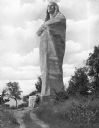
| Date: | |
|---|---|
| Description: | Sculpted by Lorado Taft, and dedicated in 1911, this statue of a Native American man wrapped in a blanket stands 48 feet tall and was originally named "The... |
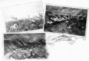
| Date: | 1862 |
|---|---|
| Description: | A composite of three views showing the siege of New Ulm on August 19 during the Indian Massacre of 1862. The lower left view depicts wagons and horses on a... |

| Date: | 1930 |
|---|---|
| Description: | This map shows Indian trails through Wisconsin counties. The trail are in red ink. Lake Michigan, Green Bay, Lake Superior, and the Wisconsin River are lab... |

| Date: | 1922 |
|---|---|
| Description: | A map of Iron County, Wisconsin, shows sections and the towns of Upson, Hurley, Hamilton, Saxon, and Mercer, lakes and streams, villages, railroads, roads ... |

| Date: | 1925 |
|---|---|
| Description: | This 1925 map of Ashland County, Wisconsin, shows the township and range system, towns, sections, cities and villages, the Bad River Indian Reservation, ra... |

| Date: | 1974 |
|---|---|
| Description: | This 1968 map identifies resorts in the Lac du Flambeau Indian Reservation region of Wisconsin, covering parts of Iron, Vilas, Oneida, and Price counties. ... |

| Date: | 1873 |
|---|---|
| Description: | This 1873 map of Chippewa County, Wisconsin, which at the time also encompassed all or part of Price, Rusk, Sawyer, and Taylor counties, shows the township... |

| Date: | 1960 |
|---|---|
| Description: | This manuscript map of Taylor County, Wisconsin, shows the township and range grid, lakes and streams, "Chippewa trails, Indian trails" Indian villages and... |

| Date: | 1909 |
|---|---|
| Description: | This 1909 map of northern Wisconsin and a portion of Michigan's Upper Peninsula shows the Lac du Flambeau Indian Reservation, cities and villages, railroad... |

| Date: | 1835 |
|---|---|
| Description: | Shows Walker’s Point, Juneau Town and Kilbourn Town, including labeled buildings, trails and Indian villages. Relief shown by hachures. Oriented with north... |

| Date: | 1800 |
|---|---|
| Description: | This map is pencil on tracing paper and shows marshes, the Wisconsin River, Indian trails, and Indian boundary line. The upper left corner reads: "Let sect... |

| Date: | 1941 |
|---|---|
| Description: | This map is ink and watercolor on cardboard and shows Native American legends and villages pictorially. Trails are also shown. |
If you didn't find the material you searched for, our Library Reference Staff can help.
Call our reference desk at 608-264-6535 or email us at: