 Filter: Categories of Wisconsin Historical Images
Filter: Subject of indians of north america
Filter: Subject of state parks and reserves
Filter: Categories of Wisconsin Historical Images
Filter: Subject of indians of north america
Filter: Subject of state parks and reserves

| Date: | 1939 |
|---|---|
| Description: | A color, pictorial map. Scale: 10 miles to the inch. Shows state parks and forests, proposed state parkways, proposed state monuments and memorials, nation... |
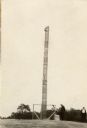
| Date: | 1930 |
|---|---|
| Description: | A totem pole erected in 1927 in honor of the aboriginal inhabitants of Wisconsin. Potawatomi chief Simon Onanguisse Kahquados (1851-November 27, 1930), an ... |
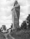
| Date: | |
|---|---|
| Description: | Sculpted by Lorado Taft, and dedicated in 1911, this statue of a Native American man wrapped in a blanket stands 48 feet tall and was originally named "The... |
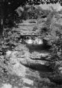
| Date: | 1925 |
|---|---|
| Description: | The Raddatz Natural Bridge and Rock Shelter, now in Natural Bridge State Park, established in 1972. |

| Date: | 1952 |
|---|---|
| Description: | The famous Dells of the Wisconsin River. A souvenir map embellished with bits of history and points of interest. |
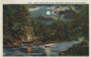
| Date: | 1913 |
|---|---|
| Description: | Colorized postcard view of the Brule River flowing through the forest by moonlight. Some trees show autumn color. There is a campfire on the shore with thr... |

| Date: | 06 1934 |
|---|---|
| Description: | This Wisconsin Conservation Department map shows national, state, and county forests both approved and pending, as well as Indian reservations in Wisconsin... |

| Date: | 1937 |
|---|---|
| Description: | This map shows the Wisconsin Conservation Department forest protection divisions and the locations of state forests, national forests, Indian reservations,... |

| Date: | 1937 |
|---|---|
| Description: | This Wisconsin Conservation Department map shows the locations of state forests, national forests, county forests, state nurseries, Indian reservations, st... |

| Date: | 05 01 1938 |
|---|---|
| Description: | This map shows the locations of Wisconsin Conservation Department forest protection districts and cooperative areas, state forests, national forests, India... |

| Date: | 1939 |
|---|---|
| Description: | This nine-part map from the U.S. Bureau of Public Roads identifies federal and state highways in Wisconsin by pavement type. County, forest, park, and publ... |

| Date: | 1944 |
|---|---|
| Description: | This nine-part map from the U.S. Bureau of Public Roads identifies federal and state highways in Wisconsin by pavement type. County, forest, park, and publ... |

| Date: | 1950 |
|---|---|
| Description: | This road map shows federal, state and county roads in Wisconsin, northern Illinois, northeastern Iowa, eastern Minnesota, and the western portion of Michi... |

| Date: | 1935 |
|---|---|
| Description: | Two hand-colored maps of the area comprising the town of Millston (Plats of Townships 20 and 21 north, range 2 west), Jackson County, Wisconsin, showing 40... |
| Date: | |
|---|---|
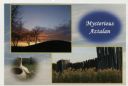
| Description: | Photographic postcard view of three views from Aztalan State Park; Indian Mound at sunset, pottery, and a fence. |
| Date: | |
|---|---|
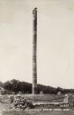
| Description: | The totem pole has a carved wooden bear clinging to the top. The totem pole was erected in 1927 in honor of the aboriginal inhabitants of Wisconsin. Potawa... |
| Date: | 08 1950 |
|---|---|
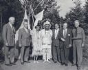
| Description: | Group portrait of six men and one woman, taken at the headwaters of the Mississippi River, Itasca State Park. C.L. (Neal) Harrington is standing at the far... |

| Date: | 1935 |
|---|---|
| Description: | This topographical map of the forest preserve shows highways, roads, trails, telephone lines, Native American reservations, Ranger sub-stations, state nurs... |

| Date: | 1939 |
|---|---|
| Description: | This illustrated map shows counties, highways, rivers, roads, present and proposed state parks and forests, proposed state parkways, proposed state monumen... |

| Date: | 1935 |
|---|---|
| Description: | This map shows the state trunk highway system and county trunk highways. This map show surface type on state and county trunk highways and the locations of... |
If you didn't find the material you searched for, our Library Reference Staff can help.
Call our reference desk at 608-264-6535 or email us at: