Filter: Categories of Wisconsin Historical Images
Filter: Subject of indians of north america
Filter: Subject of roads
Filter: Categories of Wisconsin Historical Images
Filter: Subject of indians of north america
Filter: Subject of roads

| Date: | 1936 |
|---|---|
| Description: | This map is red and black ink on tracing cloth and is oriented with north to the upper left. This hand-drawn map shows a central portion of the military ro... |

| Date: | 06 27 1927 |
|---|---|
| Description: | Aerial view of the effigy mound on Henry Wehmhoff's Riverview Farm. State Trunk Highway 83 runs through the effigy. |
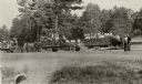
| Date: | |
|---|---|
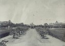
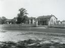
| Description: | Harrell International Institute grounds. A few people stroll and relax among the trees. |
| Date: | |
|---|---|
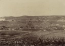
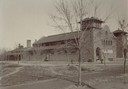
| Description: | Elevated view of grounds and buildings of the Pima Agency, near Phoenix. |
| Date: | |
|---|---|
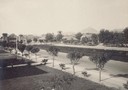
| Description: | Grounds and buildings of the Pima Agency, near Phoenix. A long, tree-lined road leads up to an office building, behind which flies an American flag. |
| Date: | |
|---|---|
| Description: | A church at the Pima Agency, near Phoenix. Children gather around the entrance, while one boy sweeps the road. |
| Date: | 1929 |
|---|---|
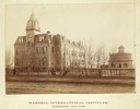
| Description: | Keshena Indian School, an Indian Government School building. |
| Date: | |
|---|---|
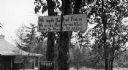
| Description: | A toll road sign on the Keshena Menominee Reservation for the Highway 55 toll road that goes through the reservation. |
| Date: | |
|---|---|
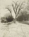
| Description: | The Black Hawk Tree growing in the middle of the street, now East Black Hawk Avenue. There are houses on the left and the road is lined with trees planted... |
| Date: | 05 29 1931 |
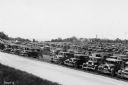
|---|---|
| Description: | A large numbers of cars are shown parked at Peninsula State Park during the reburial ceremony for Potawatomi Chief Simon Onanguisse Kahquados. A crowd of p... |

| Date: | 1915 |
|---|---|
| Description: | A row of conical burial mounds adjoins the Park and Pleasure Drive on the north shore of Lake Wingra (now Edgewood Drive, at the south edge of Edgewood Col... |

| Date: | 1939 |
|---|---|
| Description: | A color, pictorial map. Scale: 10 miles to the inch. Shows state parks and forests, proposed state parkways, proposed state monuments and memorials, nation... |
| Date: | 1933 |
|---|---|
| Description: | Native Americans hired to assist with the White Pine Blister Rust eradication effort on the Menominee Reservation are being trucked to their work site. |
| Date: | 1935 |
|---|---|
| Description: | U.S. Department of the Indian agency building on the Menominee Indian Reservation. |

| Date: | 1936 |
|---|---|
| Description: | A view of the Indian Agency house after restoration. A person is standing on the porch. |
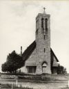
| Date: | 1900 |
|---|---|
| Description: | Hobart Episcopal Church on the Oneida Indian Reservation. |
| Date: | |
|---|---|
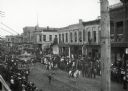
| Description: | Crowds of individuals assembled on the sides of the street to watch parading soldiers, and Native Americans riding horses. Looking east on Main Street from... |
| Date: | 04 1954 |
|---|---|
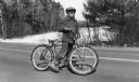
| Description: | A young Menominee Indian (Charles ?) pauses briefly for a photograph while straddling his bicycle. He is stopped on the road with the snow-covered Wolf Riv... |
| Date: | 1893 |
|---|---|
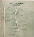
| Description: | Plat map of Brothertown in Calumet County. |
If you didn't find the material you searched for, our Library Reference Staff can help.
Call our reference desk at 608-264-6535 or email us at: