 Filter: Categories of Wisconsin Historical Images
Filter: Subject of indians of north america
Filter: Subject of maps
Filter: Categories of Wisconsin Historical Images
Filter: Subject of indians of north america
Filter: Subject of maps

| Date: | 07 1838 |
|---|---|
| Description: | A map diagram of Indian effigy mounds seven miles east of Blue Mounds in the Wisconsin Territory. |

| Date: | 1655 |
|---|---|
| Description: | Frontispiece to Newe Welt vnd americanische Historien (1655). |

| Date: | 1933 |
|---|---|
| Description: | Map created by International Harvester entitled: "The United States as it appeared in 1831 when Cyrus Hall McCormick invented the Reaper." The map pinpoint... |

| Date: | 10 1968 |
|---|---|
| Description: | During a visit to Menominee County, Secretary of the Interior Stuart Udall and Senator Gaylord Nelson learn about a proposed resort complex. |

| Date: | 1837 |
|---|---|
| Description: | Copy of N.F. Hyer's original map of Aztalan as published in the Milwaukee Advertiser, February 25, 1837. |
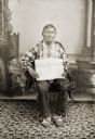
| Date: | |
|---|---|
| Description: | Full-length studio portrait of an elderly Ho-Chunk man posing sitting in front of a painted backdrop. Green Grass (HaWinChoKah) is wearing floral beaded Ho... |
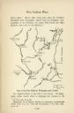
| Date: | |
|---|---|
| Description: | Hand-drawn map of the location of the Fox Indian Wars. |

| Date: | 1942 |
|---|---|
| Description: | Holiday card with a silhouette of a soldier with his gun, walking across a map of Germany outlined in red. The word "GERMANY" is printed in gray over it. I... |

| Date: | |
|---|---|
| Description: | Prehistoric Indian earthworks on the middle fork of the Duck River. |

| Date: | 1806 |
|---|---|
| Description: | Prehistoric Indian fortification on Hurricane Creek. |

| Date: | |
|---|---|
| Description: | Map of prehistoric mounds near the Big Kanawha River. |

| Date: | |
|---|---|
| Description: | Ink and watercolor of prehistoric mounds near the mouth of Haigs Creek and the Scioto River. |

| Date: | 01 20 1945 |
|---|---|
| Description: | Label submitted to the State of Wisconsin for trademark registration. Features the shape of the state of Wisconsin outlined in blue and filled in with yell... |

| Date: | |
|---|---|
| Description: | Back, front, and inside front cover of the menu from The Restaurant at Baron's department store, with "A Historical Map of Madison" focusing on the isthmus... |
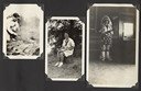
| Date: | |
|---|---|
| Description: | Page from Joy Camps photo album displaying three photographs. In one photograph Barbara Ellen Joy, camp owner and co-director, cooks over a large grill are... |

| Date: | 1914 |
|---|---|
| Description: | This map shows township grids, railroads, roads, and drainage. The area of the map covers northeastern Wisconsin and Menominee Indian reservation. Green Ba... |

| Date: | 1840 |
|---|---|
| Description: | This map is pencil on paper and shows rivers, granite locations, and selected landmarks. Relief is shown by hachures. |

| Date: | 1940 |
|---|---|
| Description: | This blue line print map traced from aerial survey mosaic shows reservation boundary, roads, trails, and railroads. Color manuscript annotations show triba... |

| Date: | 1925 |
|---|---|
| Description: | This map shows trails, mounds, villages, corn fields, and contemporary civil townships; some villages and features include both Indian and English place na... |
If you didn't find the material you searched for, our Library Reference Staff can help.
Call our reference desk at 608-264-6535 or email us at:
