 Filter: Categories of Wisconsin Historical Images
Filter: Subject of indians of north america
Filter: Subject of livestock
Filter: Categories of Wisconsin Historical Images
Filter: Subject of indians of north america
Filter: Subject of livestock

| Date: | 1937 |
|---|---|
| Description: | Pictorial map showing historical events and locations within the state of Wisconsin, as well as waterways and counties. Original caption on the bottom marg... |
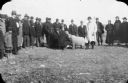
| Date: | 1925 |
|---|---|
| Description: | A man in a light-colored overcoat, possibly Joseph Wojta, standing behind a sheep being inspected by two other men. A group, including men, women and child... |
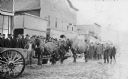
| Date: | 1925 |
|---|---|
| Description: | View across unpaved road towards a Native American man wearing a plaid overcoat with two work horses. A crowd of men are watching from the elevated wooden ... |

| Date: | 1920 |
|---|---|
| Description: | A handwritten sign identifies the "Shing-Wak Stock Farm, John B. Breselle (?) Prop., Dealer in Draft Horses." It also advertises "Green Mountain Seed Potat... |

| Date: | 1671 |
|---|---|
| Description: | Map of Virginia depicting the discoveries detailed by John Smith in his exploration of the region. It shows Jamestown, Native American tribes and villages,... |
If you didn't find the material you searched for, our Library Reference Staff can help.
Call our reference desk at 608-264-6535 or email us at: