 Filter: Categories of Wisconsin Historical Images
Filter: Subject of indians of north america
Filter: Subject of lakes
Filter: Categories of Wisconsin Historical Images
Filter: Subject of indians of north america
Filter: Subject of lakes

| Date: | 1936 |
|---|---|
| Description: | This map is red and black ink on tracing cloth and is oriented with north to the upper left. This hand-drawn map shows a central portion of the military ro... |

| Date: | 1893 |
|---|---|
| Description: | Back of painting reads: "Madison in June 1837 after photo taken by E.E. Bailey" and "Peck's cabin by Dengel." The Eben Peck cabin was the first house built... |

| Date: | |
|---|---|
| Description: | The Eben Peck cabin was the first house built in Madison. |

| Date: | 1886 |
|---|---|
| Description: | This map shows U.S. land offices, completed railroads, railroad land grant limits, lakes, rivers, and Indian reservations. Communities, lakes, and rivers a... |

| Date: | 06 1837 |
|---|---|
| Description: | Lithograph based on a painting by Mrs. E.E. Bailey showing the Peck cabin, the first house in Madison. In addition to the cabin, the lithograph includes a ... |

| Date: | 1835 |
|---|---|
| Description: | Little Lake Butte Des Morts just north of Lake Winnebago where Governor Lewis Cass of Michigan, and Thomas McKenney, head of the Bureau of Indian Affairs (... |
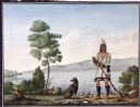
| Date: | |
|---|---|
| Description: | Watercolor of Canadian Prairie Indian at lake's shore with gun in hand and a recently hunted duck on the ground. A dog is at his feet. On the far shoreline... |
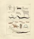
| Date: | 1851 |
|---|---|
| Description: | Pictographs on Lake Superior and Carp River, Mich. Six rows of animals, canoes, birds, human figures, and other symbols. |
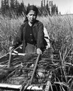
| Date: | 1960 |
|---|---|
| Description: | An Ojibwa woman, Francis Mike, harvesting wild rice in a boat on Totogatic Lake. |
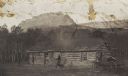
| Date: | |
|---|---|
| Description: | Norris' flat at Upper St. Mary's Lake, with men standing in front of the cabin. |
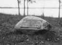
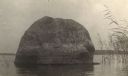
| Date: | |
|---|---|
| Description: | View of a rock with a plaque that reads: "Group of Prehistoric Indian Burial Mounds and Winnebago Village Site. Marked by the Delavan Woman's Club - May 19... |
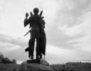
| Date: | 1963 |
|---|---|
| Description: | Statue of Winnebago Indian Chief Red Bird, with Lake Winnebago in the background. |
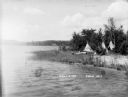
| Date: | |
|---|---|
| Description: | Three tipis on the shore of East Lake, now called Lake Tahkodah. |
| Date: | |
|---|---|
| Description: | Tipis along the shore of East Lake, now called Lake Tahkodah. |
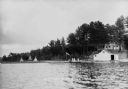
| Date: | |
|---|---|
| Description: | People on the shore of East Lake (now called Lake Tahkodah) by the Gifford residence, with tipis in the distance. |
| Date: | 1905 |
|---|---|
| Description: | Rock near the principal village of the Chippewa Indian Reservation. |
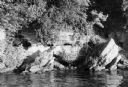
| Date: | 01 07 1973 |
|---|---|
| Description: | The legendary Black Hawk Cave on the south shore of Lake Mendota, where Black Hawk allegedly hid from white troopers during the Black Hawk War. |

| Date: | 1877 |
|---|---|
| Description: | Map showing location of Indian reservations in the United States and population figures. |
| Date: | 1877 |
|---|---|
| Description: | Photograph of a painting of the exterior of the Eben Peck cabin by Mrs. E.E. Bailey. The location of this original painting is unknown. |

| Date: | 1939 |
|---|---|
| Description: | A color, pictorial map. Scale: 10 miles to the inch. Shows state parks and forests, proposed state parkways, proposed state monuments and memorials, nation... |
If you didn't find the material you searched for, our Library Reference Staff can help.
Call our reference desk at 608-264-6535 or email us at: