Filter: Categories of Wisconsin Historical Images
Filter: Subject of indians of north america
Filter: Subject of international relations
Filter: Categories of Wisconsin Historical Images
Filter: Subject of indians of north america
Filter: Subject of international relations

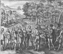
| Date: | 1655 |
|---|---|
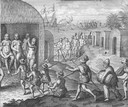
| Description: | Encounter with Indians during Christopher Columbus' first expedition in 1492. |
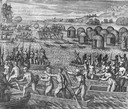
| Date: | 1655 |
|---|---|
| Description: | Scene from the Vespucci Expedition, 1499. |
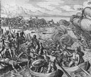
| Date: | 1655 |
|---|---|
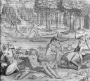
| Description: | Battle during the Vespucci Expedition, 1499. |
| Date: | 1655 |
|---|---|
| Description: | Scene from the Vespucci Expedition, 1499. |
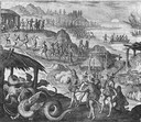
| Date: | 1655 |
|---|---|
| Description: | Scene from Vespucci Expedition, 1499. |

| Date: | 1655 |
|---|---|
| Description: | Girolamo Benzoni (1519-1570) was an Italian from Milan who spent the years 1541-1556 in the New World. His observations of Spanish imperialism were publish... |
| Date: | 1655 |
|---|---|
| Description: | Girolamo Benzoni (1519-1570) was an Italian from Milan who spent the years 1541-1556 in the New World. His observations of Spanish imperialism were publish... |
| Date: | 1655 |
|---|---|
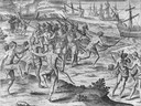
| Description: | Scene from Drake Expedition near Rio de la Plata, Brazil, ca. 1578. |
| Date: | 1655 |
|---|---|
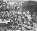
| Description: | Scene from the Jamestown Settlement in Virginia, 1607. |

| Date: | 1720 |
|---|---|
| Description: | One of Herman Moll's most famous maps, often referred to as The Beaver Map for its elaborate engraved inset depicting and describing beavers building a dam... |

| Date: | 1720 |
|---|---|
| Description: | This map of North America shows cities, rivers, lakes, and a few topographical features, complete with numerous descriptive blocks of text about expedition... |

| Date: | 1746 |
|---|---|
| Description: | Map of North America from the southern portion of James Bay to Florida. It shows the colonies, cities, Native American land, and topological and geographic... |

| Date: | 1758 |
|---|---|
| Description: | This map of the north-west hemisphere shows the cities, lakes, rivers, mountains, and political borders. In the upper left corner sits a decorative cartouc... |

| Date: | 1755 |
|---|---|
| Description: | This map shows forts, missions, villages and cities, rivers and portages, and boundaries of the Spanish, English, and French territories, marking the large... |

| Date: | 1757 |
|---|---|
| Description: | This map shows the cities, plantations, lakes, rivers, mountains, Native American territories and colonial borders of the Eastern half of North America, pl... |

| Date: | 1755 |
|---|---|
| Description: | This map shows the eastern half of North America during the French and Indian war, including cities, borders, Native American Land, forts, and detailed geo... |

| Date: | 1782 |
|---|---|
| Description: | Map of the West Indies and south eastern North America, remarkably detailed, showing cities, mountains, rivers, lakes, mines, plantations, forts, banks, an... |

| Date: | 1791 |
|---|---|
| Description: | An English and updated version of d'Anville's 1746 map "Amérique Septentrionale Publiée sous les Auspices de Monseigneur le Duc d'Orleans Prémier Prince du... |

| Date: | 1783 |
|---|---|
| Description: | This map is hand-colored and shows the boundaries of British, Spanish, and the newly recognized American claims, as well as the fishing rights granted to F... |
If you didn't find the material you searched for, our Library Reference Staff can help.
Call our reference desk at 608-264-6535 or email us at: