 Filter: Categories of Wisconsin Historical Images
Filter: Subject of indians of north america
Filter: Subject of farms
Filter: Categories of Wisconsin Historical Images
Filter: Subject of indians of north america
Filter: Subject of farms

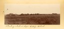
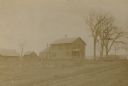
| Date: | 06 27 1927 |
|---|---|
| Description: | Aerial view of the effigy mound on Henry Wehmhoff's Riverview Farm. State Trunk Highway 83 runs through the effigy. |
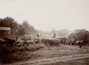
| Date: | |
|---|---|
| Description: | Men thresh huge piles of wheat at the Seger Colony School. |

| Date: | 1858 |
|---|---|
| Description: | On a very hot day in August 1858 Hölzlhuber visited the farm of Jack Smith, an Irishman who had immigrated to Canada eleven years previously with his wife ... |
| Date: | 1902 |
|---|---|
| Description: | Alfalfa fields, cultivated by Indians, at the Pyramid Lake Agency. |
| Date: | |
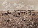
|---|---|
| Description: | Indians thresh the first wheat at the Sac and Fox Agency in Iowa. |
| Date: | |
|---|---|
| Description: | Indians start the first McCormick self-binders at the Sac and Fox Agency in Iowa. |
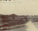
| Date: | 1897 |
|---|---|
| Description: | The Indian Agency House when the land was farmed by E.S. Baker of Portage, Wisconsin. |
| Date: | |
|---|---|
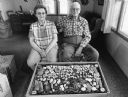
| Description: | Vernon and Cathrine Steger proudly display a lifetime collection of Native American artifacts found on their farm. |
| Date: | 1958 |
|---|---|
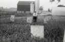
| Description: | Local historian William F. Wolf visiting the Native American cemetery. In the background is a barn and a silo and other farm buildings. |

| Date: | |
|---|---|
| Description: | A map that shows the Wisconsin Central Railway land grant lands for sale by the Soo Line, the Chicago, Milwaukee, and St. Paul Railway. Town sections, lak... |

| Date: | |
|---|---|
| Description: | Map of northern Iron County, Wisconsin, shows town sections and railroads in the towns of Saxon, Kimball, and Gurney. It also includes the area of the La P... |

| Date: | 1898 |
|---|---|
| Description: | This 1898 map of Sawyer County, Wisconsin, shows the township and range system, sections, roads, farm houses, camps, school houses, dams, bridges, Indian r... |

| Date: | 1902 |
|---|---|
| Description: | This 1902 map of the eastern portion of Sawyer County, Wisconsin, shows the township and range system, sections, roads, farm houses, camps, school houses, ... |

| Date: | 1890 |
|---|---|
| Description: | This map shows the Wisconsin Central Railroad land grant lands owned and for sale by the Soo Line in Ashland County, Wisconsin, as well as in portions of B... |

| Date: | 1890 |
|---|---|
| Description: | This 1890s map shows the Wisconsin Central Railroad land grant lands owned and for sale by the Soo Line in Ashland County, Wisconsin, as well as in the eas... |

| Date: | 1894 |
|---|---|
| Description: | Catalog cover featuring illustrations along with the text: "The Foreign Commisioners Visit the Northwest, and Learn Why Bonanza Farming Pays." At the top i... |

| Date: | 1838 |
|---|---|
| Description: | This map is a development plat that shows street names, numbered blocks and lots, and small farm lot owners. Included on the right of the map is a large am... |

| Date: | 1915 |
|---|---|
| Description: | This map shows school houses, churches, farms, and railroads. Chequamecon Bay and Bad River Indian Reservation are labeld. The map reads: "All lands shown ... |

| Date: | 1911 |
|---|---|
| Description: | This map shows railroads, roads, swamps, a school site and farm, and a mill site. The map includes a "typical township" diagram. Lac du Flambeau, Long Lake... |

| Date: | 1935 |
|---|---|
| Description: | This map shows railroads, telephone lines, roads, trails, schools, sub-agency, lookout stations, churches, community centers, and school site and farm. Bil... |
If you didn't find the material you searched for, our Library Reference Staff can help.
Call our reference desk at 608-264-6535 or email us at: