 Filter: Categories of Wisconsin Historical Images
Filter: Subject of indians of north america
Filter: Subject of clothing and dress
Filter: Year of 1700-1799
Filter: Categories of Wisconsin Historical Images
Filter: Subject of indians of north america
Filter: Subject of clothing and dress
Filter: Year of 1700-1799
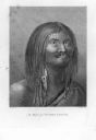
| Date: | 1784 |
|---|---|
| Description: | Plate 38. Portrait from Cook's Third Expedition, 1776-1779, while in Alaska. |
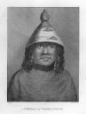
| Date: | 1784 |
|---|---|
| Description: | Plate 39. Portrait from Cook's Third Expedition, 1776-1779, while in Alaska. |

| Date: | 1784 |
|---|---|
| Description: | Plate 41. Scene from Cook's Third Expedition, 1776-1779, while in Alaska. |

| Date: | 1784 |
|---|---|
| Description: | Plate 42. Scene from Cook's Third Expedition, 1776-1779, while in Alaska. |
| Date: | 1784 |
|---|---|
| Description: | Plate 46. Portrait from Cook's Third Expedition, 1776-1779, while in Alaska. |

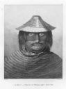
| Date: | 1784 |
|---|---|
| Description: | Plate 47. Portrait from Cook's Third Expedition, 1776-1779, while in Alaska. |
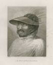
| Date: | 1784 |
|---|---|
| Description: | Plate 48. Portrait from Cook's Third Expedition, 1776-1779, while in Alaska. |
| Date: | 1784 |
|---|---|
| Description: | Plate 49. Portrait from Cook's Third Expedition, 1776-1779, while in Alaska. |

| Date: | 1784 |
|---|---|
| Description: | Plate 50. Portrait from Cook's Third Expedition, 1776-1779, while in Alaska. |
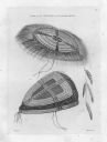
| Date: | 1784 |
|---|---|
| Description: | Plate 56. Drawing from Cook's Third Expedition, 1776-1779, while in Alaska. |

| Date: | 1784 |
|---|---|
| Description: | Plate 57. Scene from Cook's Third Expedition, 1776-1779, while in Alaska. |

| Date: | 1784 |
|---|---|
| Description: | Plate 58. Scene from Cook's Third Expedition, 1776-1779, while in Alaska. |

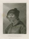
| Date: | 1766 |
|---|---|
| Description: | Portrait of Mohegan minister and preacher Samson Occom, posed sitting with his finger on a Bible on a bookstand, with Indian implements visible on the wall... |
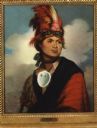
| Date: | 1786 |
|---|---|
| Description: | Print of a Gilbert Stuart painted portrait of Thayendangea (known also as Joseph Brant). He wears a feathered headdress and a shell around his neck. |

| Date: | 1790 |
|---|---|
| Description: | An updated and corrected version of Robert de Vaugondy's 1750 map "Amérique Septentrionale: Dressée sur les Relations les Plus Modernes des Voyageurs et Na... |

| Date: | 1746 |
|---|---|
| Description: | Detailed map of the western hemisphere and part of Africa and Europe. Islands, cities, settlements, rivers, lakes, countries, and regions are marked. Mount... |

| Date: | 1780 |
|---|---|
| Description: | Map of North and South America, showing the boundaries of colonial territories, cities, settlements, rivers, lakes, and Native American land. Particular em... |

| Date: | 1710 |
|---|---|
| Description: | Map of North America showing the European claims, Native American land and villages, rivers, lakes, cities, and notes on explorers, discoveries, and topogr... |

| Date: | 1719 |
|---|---|
| Description: | Map of North America showing land divisions between France, Spain, England, Sweden, Denmark and Holland. The map is detailed, labeling cities, forts, islan... |

| Date: | 1770 |
|---|---|
| Description: | Map of North America from the Great Lakes to the northern portion of South America. It shows cities, Native American land, mountains, swamps, lakes, rivers... |
If you didn't find the material you searched for, our Library Reference Staff can help.
Call our reference desk at 608-264-6535 or email us at: