 Filter: Categories of Wisconsin Historical Images
Filter: Subject of indians of north america
Filter: Subject of african americans
Filter: Categories of Wisconsin Historical Images
Filter: Subject of indians of north america
Filter: Subject of african americans

| Date: | 02 23 1920 |
|---|---|
| Description: | Wisconsin Governor Emmanuel Philipp in the Governor's Office during a conference with a delegation of Chippewa (Ojibwa) Indians. Executive Messenger Samuel... |

| Date: | |
|---|---|
| Description: | Carte-de-visite portrait of Edmonia Lewis (1845-1890), African American Sculptor. Lewis, the first famous American sculptor of African descent, had a Chipp... |

| Date: | |
|---|---|
| Description: | Portrait image of Stephen Bonga (1799-1884) pictured with a hat and walking stick. |
| Date: | |
|---|---|
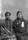
| Description: | A studio portrait of two young Ho-Chunk women posing sitting in front of a painted backdrop. They are wearing beaded necklaces, long earrings, and are wrap... |
| Date: | 1904 |
|---|---|
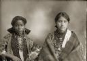
| Description: | Waist-up studio portrait of two young Ho-Chunk women posing sitting, wearing beaded necklaces and long earrings, and wrapped in shawls. Carrie Elk (ENooKah... |

| Date: | 1981 |
|---|---|
| Description: | Holiday card with the Christ child in a manger surrounded by four praying children, each of a different race, Native American, African American, Caucasian ... |
| Date: | 1982 |
|---|---|
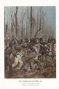
| Description: | "The painting shows the Choctaws and a mixed group of Major Daquin's Battalion of Free Men of Color. The latter were mostly attired in civilian clothes bec... |

| Date: | 1946 |
|---|---|
| Description: | This map shows scenes from America's history with names of historical events superimposed on a map of the United States. |

| Date: | 1783 |
|---|---|
| Description: | This map is hand-colored and shows the boundaries of British, Spanish, and the newly recognized American claims, as well as the fishing rights granted to F... |

| Date: | 1755 |
|---|---|
| Description: | Map of Virginia and parts of Maryland, North Carolina, and New Jersey. It shows borders, boundary lines, some Native American land, counties, cities, towns... |
If you didn't find the material you searched for, our Library Reference Staff can help.
Call our reference desk at 608-264-6535 or email us at: