Filter: Categories of Wisconsin Historical Images
Filter: Subject of human settlements
Filter: Categories of Wisconsin Historical Images
Filter: Subject of human settlements

| Date: | 12 14 1960 |
|---|---|
| Description: | A.J. Taff, Maple Bluff police marshal, 6 Fuller Drive, conducts a one-man census of the village for the annual village directory. Taff has conducted the ce... |

| Date: | 12 05 1960 |
|---|---|
| Description: | A group of truck drivers from Kenosha picketing at the State Capitol. They are protesting Interstate Commerce Commission (ICC) rate orders involving transp... |

| Date: | 11 29 1960 |
|---|---|
| Description: | The four-level home built from plans in the Wisconsin State Journal by Mr. and Mrs. Harold F. (Schim) Elliott as their "dream home" at 526 Edward st... |

| Date: | 11 25 1960 |
|---|---|
| Description: | Dan Watson, left, director of the Vilas Park Zoo, and fireman Don Annen attempting to capture two rhesus monkeys in the tree tops. Annen is holding a tran... |

| Date: | 11 25 1960 |
|---|---|
| Description: | Children watching firemen and the zoo director attempting to capture two rhesus monkeys in the tree tops. The monkeys escaped from the zoo on August 4th, 1... |

| Date: | 11 23 1960 |
|---|---|
| Description: | Ground-breaking ceremony for the Wisconsin Life Insurance Company's new office building at Segoe road and University avenue. The company president, Gordon ... |

| Date: | 11 02 1960 |
|---|---|
| Description: | The smashed-in storefront of the Time Realty Company building at 2434 University Avenue as a result of a car backing up with a stuck accelerator. |

| Date: | 10 28 1960 |
|---|---|
| Description: | University Republican students picketing the Kennedy-Nelson campaign headquarters at 610 University Avenue, carrying signs asking why the Democratic campai... |
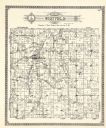
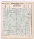
| Date: | 1922 |
|---|---|
| Description: | A plat map by Westfield created by George A. Ogle & Co. |

| Date: | 1912 |
|---|---|
| Description: | A plat map of the township of Casco. Created by Geo. A. Ogle. |

| Date: | 1891 |
|---|---|
| Description: | Page 13 of a Sanborn map of Stevens Point. |

| Date: | 1891 |
|---|---|
| Description: | The index page of a Sanborn Map of Stevens Point. |

| Date: | 1857 |
|---|---|
| Description: | Green Lake County plat map, T. 16 N, R. |

| Date: | 1857 |
|---|---|
| Description: | Green Lake County plat map, T. 17 N, R. 13 E. |

| Date: | 1857 |
|---|---|
| Description: | Green Lake County plat map, T. 15 N, R. 13 E. |

| Date: | 1857 |
|---|---|
| Description: | Green Lake County plat map, T. 14 N, R. 13 E. |

| Date: | 1857 |
|---|---|
| Description: | Green Lake County plat map, T. 16 N, R. 12 E. |

| Date: | 1857 |
|---|---|
| Description: | Green Lake County plat map, T. 17 N, R. 12 E. |

| Date: | 1857 |
|---|---|
| Description: | Green Lake County plat map, T. 14 N, R. 12 E. |
If you didn't find the material you searched for, our Library Reference Staff can help.
Call our reference desk at 608-264-6535 or email us at: