 Filter: Categories of Wisconsin Historical Images
Filter: Subject of education
Filter: Subject of land
Filter: Categories of Wisconsin Historical Images
Filter: Subject of education
Filter: Subject of land
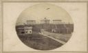
| Date: | 1865 |
|---|---|
| Description: | University of Wisconsin-Madison campus showing the first three buildings on campus, South Hall (left), University Hall [Bascom Hall] (center), and North Ha... |
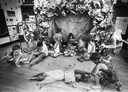
| Date: | 02 27 1984 |
|---|---|
| Description: | A sixth grade class dresses up as cave people to experience the likeness of living in pre-historic times. |
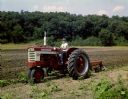
| Date: | 04 1959 |
|---|---|
| Description: | Color photograph of 4-H youth operating a Farmall 340 tractor with mounted plow. |
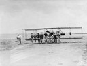
| Date: | 03 07 1912 |
|---|---|
| Description: | Students of the Curtiss School of Aviation on North Island moving a plane into position for a lesson. |
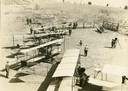
| Date: | 1912 |
|---|---|
| Description: | Photo opportunity day at the Glenn Curtiss School of Aviation on North Island in San Diego Harbor. The man in the lower left corner is thought to be Glenn ... |

| Date: | 05 1912 |
|---|---|
| Description: | The 1912 class at the Glenn Curtiss Aviation School on North Island, near San Diego. Milwaukee's John Kaminski (in white shirt and tie) is second from the ... |
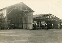
| Date: | 1912 |
|---|---|
| Description: | Hangars of the Curtiss Aviation School and the San Diego Aero Club on North Island in San Diego Harbor. Glenn Curtiss himself is thought to be the individu... |

| Date: | 1870 |
|---|---|
| Description: | Baraboo was first settled around 1838, and by 1870 it had become the county seat and the thriving village illustrated here. This birds eye drawing depicts ... |

| Date: | 1869 |
|---|---|
| Description: | Birds-eye drawing of Boscobel, Grant County, depicts street names and street layouts, houses, rivers and trees. A reference key at the bottom of the map sh... |

| Date: | 1868 |
|---|---|
| Description: | This 1868 birds-eye view depicts the buildings, streets, railroad, vegetation and topography of Columbus, Wisconsin. The high school, cemetery, railroad de... |

| Date: | 1867 |
|---|---|
| Description: | Bird's-eye map of Green Bay and Fort Howard, Brown Co., depicts street names and street layouts, houses, trees, and the East River. A reference key at the ... |

| Date: | 1870 |
|---|---|
| Description: | Bird's-eye map of Hudson, with insets of Court House and Public School. |

| Date: | 1867 |
|---|---|
| Description: | Bird's-eye map of La Crosse with nine insets of residences, schools, and the Court House and Jail. |
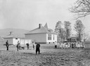
| Date: | 1917 |
|---|---|
| Description: | Boys working in a garden while smaller children dance in a circle on the grounds of Middlefield No. 2 Consolidated School in Ostego County. Teachers are lo... |

| Date: | 1875 |
|---|---|
| Description: | Bird's-eye map of Black River Falls, looking southwest. |

| Date: | 1872 |
|---|---|
| Description: | Birds-eye drawing of Eau Claire depicts street names and street locations, houses, trees, bridges, piers, canals, railroads, and the Chippewa and Eau Clair... |

| Date: | 1880 |
|---|---|
| Description: | Bird's-eye map over the Mississippi River of Fountain City. Paddle steamers and steamboats are on the river, and bluffs are in the background. |
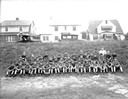
| Date: | 09 02 1931 |
|---|---|
| Description: | Outdoor group portrait of the West High School football team. Houses are on a hill in the background, and automobiles are parked in front of them. |

| Date: | 1910 |
|---|---|
| Description: | Bird's-eye view looking east, with Washburn Harbor at center and Chequamegon Bay in Lake Superior covering most of the upper image. Streets with buildings... |
If you didn't find the material you searched for, our Library Reference Staff can help.
Call our reference desk at 608-264-6535 or email us at:
