 Filter: Categories of Wisconsin Historical Images
Filter: Subject of arts
Filter: Subject of harbors
Filter: Categories of Wisconsin Historical Images
Filter: Subject of arts
Filter: Subject of harbors

| Date: | 1870 |
|---|---|
| Description: | Bird's-eye view of the city of Manitowoc with a population of 5,168 inhabitants as it appears in 1870, the year the village was granted a city charter by t... |
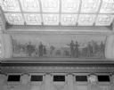
| Date: | 02 04 1945 |
|---|---|
| Description: | The mural depicts a 1915 harbor scene with a steamship, railway train, automobile, and airplane. One of four murals by Charles Yardley Turner, representing... |

| Date: | 01 04 1862 |
|---|---|
| Description: | Engraving of the city of Superior and Lake Superior, also depicting railroad piers, Minnesota Point, and the steamboat "Star". The engraving appears on a l... |

| Date: | |
|---|---|
| Description: | Arthur W. Page (far left in eyeglasses and hat), poses with business associates and a little girl in costume. The Statue of Liberty is in the background. |
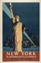
| Date: | 1934 |
|---|---|
| Description: | An original lithograph promoting both New York City as "the wonder city of the world," and train travel. Featuring the artist Adolph Treidler, the poster d... |
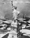
| Date: | |
|---|---|
| Description: | Elevated view of the Statue of Liberty and surrounding buildings on Liberty Island. A large ship is docked at the island and the waters of the New York Upp... |
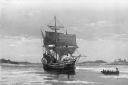
| Date: | |
|---|---|
| Description: | "The 'Mayflower' in Plymouth Harbor, Mass." A copy of the painting by William F. Halsall from the collection of the Plymouth, Massachusetts colony. Paintin... |

| Date: | |
|---|---|
| Description: | Bird's-eye view lithograph of Key West with ships and smaller boats in the surrounding waters. |

| Date: | |
|---|---|
| Description: | General view of the city's shoreline featuring a ship moored at the main pier. |

| Date: | 1874 |
|---|---|
| Description: | Engraved view of downtown Racine seen from Lake Michigan. Several vessels are entering the harbor, and a pier with a beacon is on the right. |

| Date: | 1871 |
|---|---|
| Description: | Engraved view of Kenosha harbor. A group of men fish from a pier in the foreground while several boats float through the harbor. A tug is pulling a large s... |

| Date: | 1918 |
|---|---|
| Description: | Elevated view looking down gutter of roof towards the British volunteer forces parading in Archangel [Archangelsk], Russia right before they disembarked fr... |

| Date: | 1941 |
|---|---|
| Description: | Elevated view of Sturgeon Bay in 1900. Sturgeon Bay Bridge spans the bay and several boats are on the water. A lighthouse sits on a small island in the bay... |
| Date: | |
|---|---|
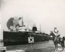
| Description: | Composite photograph in the "Tall Tale" style. An enormous bovine stands on the front deck of the Pere Marquette 21, a steamer. On the right, on the... |

| Date: | 1715 |
|---|---|
| Description: | A map of the countries and islands surrounding the Gulf of Mexico. The hand-colored borders separate the territories of England, France, Spain, and Holland... |

| Date: | 1720 |
|---|---|
| Description: | One of Herman Moll's most famous maps, often referred to as The Beaver Map for its elaborate engraved inset depicting and describing beavers building a dam... |

| Date: | 1715 |
|---|---|
| Description: | One of Herman Moll's most famous maps, often referred to as The Codfish Map, it shows rivers and portages, cities, Indian villages, wind directions, routes... |

| Date: | 1719 |
|---|---|
| Description: | Map of the British colonies and territories in North American, depicting cities, Native American land, rivers, mines, forts, trees, and topography east of ... |

| Date: | 1720 |
|---|---|
| Description: | This map of North America shows cities, rivers, lakes, and a few topographical features, complete with numerous descriptive blocks of text about expedition... |

| Date: | 1777 |
|---|---|
| Description: | Map showing the Hudson River in three sections, from New York City up through Lake Champlain, including cities, forts, roads, topographical features, and n... |
If you didn't find the material you searched for, our Library Reference Staff can help.
Call our reference desk at 608-264-6535 or email us at: