 Filter: Categories of Wisconsin Historical Images
Filter: Subject of Writing
Filter: Year of 1800-1899
Filter: Subject of transportation
Filter: Categories of Wisconsin Historical Images
Filter: Subject of Writing
Filter: Year of 1800-1899
Filter: Subject of transportation
| Date: | 1804 |
|---|---|
| Description: | Front cover of the 55-page diary, from May 14 through August 17, 1804 written by Charles Floyd, a sergeant with the Lewis and Clark expedition. |
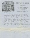
| Date: | 1857 |
|---|---|
| Description: | Letter on stationery featuring an engraving of an exterior view of the Milwaukee House showing horse-drawn vehicles and people standing on the sidewalk in ... |
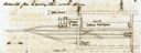
| Date: | 10 19 1847 |
|---|---|
| Description: | Sketch of the Camden Depot in a letter from John McRae to James Gadsdeg. |

| Date: | 1895 |
|---|---|
| Description: | Side view of a man sitting on a horse-drawn mower in a field. The man on the mower is writing on a piece of paper. Another man wearing a bow tie is sitting... |

| Date: | 1863 |
|---|---|
| Description: | This map is a hand-colored, pen and ink, drawing by Ole R. Dahl of Co. B, 15 Wisconsin Infantry shows the battlefield at Stones River, depicting roads, str... |
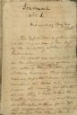
| Date: | 05 24 1820 |
|---|---|
| Description: | A page, headed with "Journal No. 1," of James Doty's journal of a trip with Cass, Schoolcraft, etc. to the sources of the Mississippi River. |

| Date: | 08 17 1874 |
|---|---|
| Description: | This manuscript drawing provides a side elevation, plan, and perspective view for a proposed lock on the Fox River. |

| Date: | 1855 |
|---|---|
| Description: | Pen-and-ink on paper. Includes certifications signed by surveyor and by "John T. Perkins, by his attorney I.A. Lapham." Inscribed and signed certification ... |
| Date: | 1887 |
|---|---|
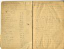
| Description: | Opening spread of Reuben Gold Thwaites' diary of his 1887 trip on the Fox River. |

| Date: | 1828 |
|---|---|
| Description: | Increase Lapham's drawing and description of an earth borer for his handwritten manuscript, Notes and Accounts of Canals, Particularly the Ohio Canal Ne... |

| Date: | 1856 |
|---|---|
| Description: | This map of Woodman's Addition in Mineral Point is pen-and-ink on paper. The map includes certifications signed by John B. Whitelaw (surveyor), Cyrus Woodm... |

| Date: | 1856 |
|---|---|
| Description: | This map is ink and pencil on paper and shows plat of the town, local streets, and blocks and lots by number. The map includes explanatory text. |

| Date: | 11 1836 |
|---|---|
| Description: | This map is pen-and-ink on paper and is a plat of a paper city on the Wisconsin River, in what is now the Town of Dekorra. The map shows lot and block numb... |

| Date: | 06 1845 |
|---|---|
| Description: | This map is pen-and-ink on paper and shows the numbers, dimensions, and acreages of lots, as well as survey monuments and streets. Also included is a certi... |
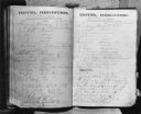
| Date: | 08 1871 |
|---|---|
| Description: | Caption reads: "Photocopy of the hotel register at the De Pere House De Pere Wis from Friday August 4 to Tuesday August 8 1871. Among names to be noted are... |
If you didn't find the material you searched for, our Library Reference Staff can help.
Call our reference desk at 608-264-6535 or email us at: