Filter: Categories of Wisconsin Historical Images
Filter: Subject of Wisconsin River (Wis.)
Filter: Categories of Wisconsin Historical Images
Filter: Subject of Wisconsin River (Wis.)

| Date: | 1820 |
|---|---|
| Description: | A manuscript map of Prairie du Chien. |

| Date: | 1840 |
|---|---|
| Description: | This map, one of a series made by Thomas Jefferson Cram of the U.S. Topographical Engineers from personal surveys, shows the portage connecting the Wiskons... |
| Date: | 1925 |
|---|---|
| Description: | Car ferry on the Wisconsin River at Merrimac. A ferry has operated at this site since the 1840's. In 1924 the privately owned ferry was replaced by this wo... |
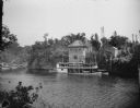
| Date: | 1922 |
|---|---|
| Description: | View from shoreline across river towards the steamboat "Winnebago" docked at the Dells Boat Landing on the opposite shoreline. |
| Date: | |
|---|---|
| Description: | Elevated view of the Dells boat landing building, with people standing on the balcony. There is a steamboat near the dock on the river below. |
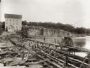
| Date: | 1895 |
|---|---|
| Description: | Munger's Mill and dam, with men standing on and around the dam. |
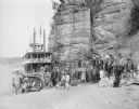
| Date: | 1929 |
|---|---|
| Description: | Ceremonial performers in traditional Indian costume pose near a steamboat. |

| Date: | |
|---|---|
| Description: | The steamboat "Winnebago" with passengers in front of the Dells Boat Landing. |

| Date: | |
|---|---|
| Description: | Rear view of flagman standing at the narrows in the Wisconsin River as a steamboat approaches. |

| Date: | 1868 |
|---|---|
| Description: | Showing the counties, towns and railroads. Partly colored. Scale: 1 inch = 20 miles. |
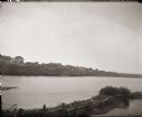
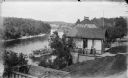
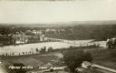
| Date: | 1900 |
|---|---|
| Description: | Slightly elevated view towards buildings in Prairie du Sac from the east bank of the Wisconsin River. |
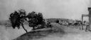
| Date: | 1850 |
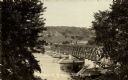
|---|---|
| Description: | Buildings along Wisconsin River. |
| Date: | |
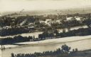
|---|---|
| Description: | Elevated view of buildings lining the river in foreground, with farmland in background. Caption reads: "Bird's Eye View of Prairie Du Sac, Wis." |
| Date: | 1908 |
|---|---|
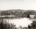
| Description: | Elevated view from shoreline of toll bridge across the Wisconsin River. Caption reads: "A Glimpse of Pr-Du-Sac Toll Bridge." |
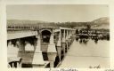
| Date: | 1922 |
|---|---|
| Description: | View along side of bridge over the Wisconsin River, built in 1921 to take the place of the old wooden one when it became condemned. Caption reads: "Wis. Ri... |
| Date: | 1922 |
|---|---|
| Description: | Elevated view of bridge over Wisconsin River built in 1921 to take the place of the old wooden bridge when it became condemned. Caption reads: "Prairie Du ... |

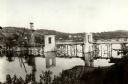
| Date: | 1910 |
|---|---|
| Description: | This was the first bridge built across the Wisconsin River, constructed about 1850, although it was not opened to traffic until 1852. It was torn down in 1... |
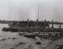
| Date: | 1920 |
|---|---|
| Description: | View from shoreline of toll bridge under construction. |
If you didn't find the material you searched for, our Library Reference Staff can help.
Call our reference desk at 608-264-6535 or email us at: