 Filter: Categories of Wisconsin Historical Images
Filter: Subject of Wisconsin River (Wis.)
Filter: Year of 1800-1899
Filter: Categories of Wisconsin Historical Images
Filter: Subject of Wisconsin River (Wis.)
Filter: Year of 1800-1899

| Date: | 1868 |
|---|---|
| Description: | This map includes a table of estimated costs "by Brev. Maj. Gen. G.K. Warren Maj. U.S.E., of improvement of Wis. River from his survey of 1867." Included a... |
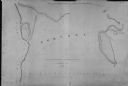
| Date: | 1839 |
|---|---|
| Description: | This map oriented with north to the upper right shows portage between the Wisconsin and Fox Rivers, as well as line of proposed construction for defense ag... |

| Date: | 1805 |
|---|---|
| Description: | Map of the United States. It shows the states, cities, towns, Native American land, mountains, lakes, and rivers. Tennessee, Kentucky, and Ohio are labeled... |

| Date: | 1800 |
|---|---|
| Description: | Map of the United States. It shows the states, including Tennessee, cities, towns, Native American land, mountains, lakes, and rivers. Lead mines appear ju... |
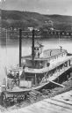
| Date: | 1870 |
|---|---|
| Description: | Elevated view of the steamer Ellen Hardy at dock. Text on the bottom left reads: "'Ellen Hardy' at Pr-Du-Sac. in 1870." The Ellen Hardy belo... |

| Date: | 09 03 1882 |
|---|---|
| Description: | Elevated view of the steamboat Alexander Mitchell and the back of a second unidentified steamboat at a dock. Captain Dave and most of the passengers... |

| Date: | 09 04 1882 |
|---|---|
| Description: | Elevated view of the steamboat Alexander Mitchell at a dock. Captain Dave and most of the passengers on the lower level are posing standing. There i... |

| Date: | 09 04 1882 |
|---|---|
| Description: | Elevated view across water towards the steamboat Alexander Mitchell moored in the canyon along the shoreline. Captain Dave and passengers are posing... |

| Date: | 07 14 1883 |
|---|---|
| Description: | Elevated view from shoreline of the steamboat Alexander Mitchell docked at the edge of the river. Captain Dave and passengers are posing on board. B... |

| Date: | 1890 |
|---|---|
| Description: | A tall pine tree is standing just in front of Stand Rock, with the Wisconsin River in the background. |

| Date: | 1896 |
|---|---|
| Description: | View along shoreline of the Wisconsin River, with a sandy beach leading to a stand of trees on the bank on the right. Buildings are along the opposite bank... |

| Date: | 1845 |
|---|---|
| Description: | Map of Wisconsin, including lower western border with Iowa, southern border along Illinois, eastern shoreline of Lake Michigan, and northern area along Wis... |

| Date: | 1875 |
|---|---|
| Description: | One of a set of maps from G.K. Warren's 1876 Report on the transportation route along the Wisconsin and Fox rivers in the State of Wisconsin between the Mi... |

| Date: | 1892 |
|---|---|
| Description: | A Sanborn fire insurance map of Sauk City which was drawn up in 1892. |
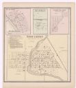
| Date: | 1873 |
|---|---|
| Description: | A page showing four plat maps: Stoughton, Clifton, Deanville, and Cross Plains. |

| Date: | 1891 |
|---|---|
| Description: | The index page of a Sanborn Map of Stevens Point. |
If you didn't find the material you searched for, our Library Reference Staff can help.
Call our reference desk at 608-264-6535 or email us at: